|
|
|
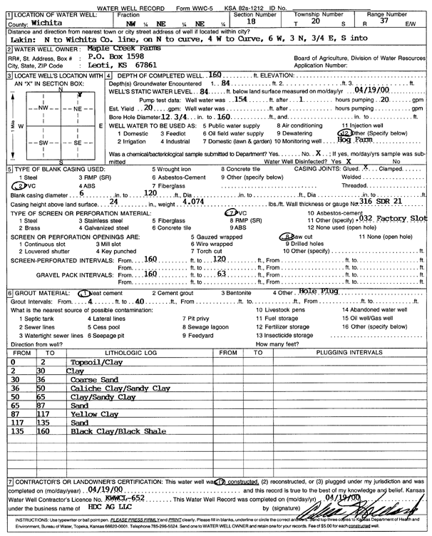
Specific Water Well Detail |
|
|
| Location Info | |||
| Owner: Maple Creek Farms | Status: Constructed | ||
| Location: T20S, R37W, Sec. 18, NW NE NE | County: Wichita | ||
| Directions: Lakin: N to Wichita Co. ln, N to curve, 4 W to Curve, 6 W, 3 N, .75 E, S in | |||
| Latitude: 38.3207271 | Longitude: -101.4420343 | Datum NAD 27 | |
| Latitude: 38.3207453 | Longitude: -101.4424767 | Datum NAD 83 | |
| Longitude and latitude calculated by Survey from township-range-section-quarter calls. Only good to within the quarter call accuracy. | |||
| View well on interactive map | |||
| General Info | ||
| Well Depth: 160 ft. | Elevation: ft. | |
| Static Water Level: 84 ft. | Est. Yield: 20 gpm. | |
| Comp. Date: 19-Apr-2000 | Well Use: Feedlot | |
| DWR Applic. #: | Other ID: | |
| Driller Info | ||
| Driller: H.D.C. AG, LLC | License #: 652 | |
| Scanned Form | View scan |
|
Chemical Sample Submitted?:
Water Well disinfected?: | ||
| Casing Info | ||
| Casing Type:
Casing Joints: |
Diam: in. to ft | |
| Casing height above land surface: in
Casing Weight: lbs/ft Wall thickness or gauge no.: | ||
| Screen and Perforation Info | ||
| Screen Type: | Screen Openings: | |
| Screen-perforated intervals | From: ft to ft | |
| Gravel pack intervals | From: ft to ft | |
| Grout Info | ||
| Grout used: | From: to ft | |
| Source of Possible Contamination | ||
| Source: | ||
| Direction from well: | Distance: ft | |
| Lithologic Log
(Log data entered by KGS.) | ||
| From: 0 ft. to 2 ft. | Top soil and clay | |
| From: 2 ft. to 30 ft. | Clay | |
| From: 30 ft. to 36 ft. | Coarse sand | |
| From: 36 ft. to 50 ft. | Caliche clay and sandy clay | |
| From: 50 ft. to 65 ft. | Clay and sandy clay | |
| From: 65 ft. to 87 ft. | Sand | |
| From: 87 ft. to 117 ft. | Yellow clay | |
| From: 117 ft. to 135 ft. | Sand | |
| From: 135 ft. to 160 ft. | Black clay and black shale | |