|
|
|
Specific Water Well Detail |
|
|
| Location Info | |||
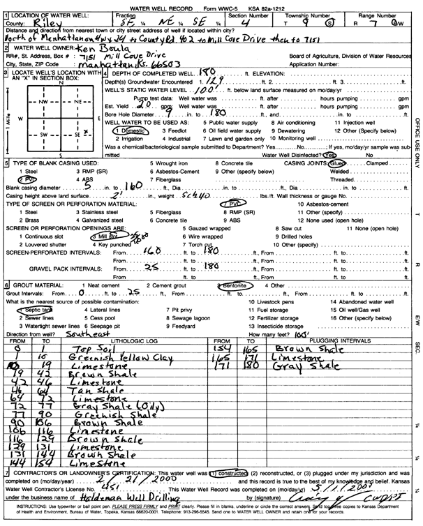
| Owner: Boula, Ken | Status: Constructed | ||
| Location: T9S, R7E, Sec. 4, SE NE SE | County: Riley | ||
| Directions: from Manhattan: N on Hw 29 to Co. Rd, 402 to Mill Cove Drive, to 7151 | |||
| Latitude: 39.2953728 | Longitude: -96.6454333 | Datum NAD 27 | |
| Latitude: 39.2953692 | Longitude: -96.6457169 | Datum NAD 83 | |
| Longitude and latitude calculated by Survey from township-range-section-quarter calls. Only good to within the quarter call accuracy. | |||
| View well on interactive map | |||
| General Info | ||
| Well Depth: 180 ft. | Elevation: ft. | |
| Static Water Level: 100 ft. | Est. Yield: 20 gpm. | |
| Comp. Date: 21-Feb-2000 | Well Use: Domestic | |
| DWR Applic. #: | Other ID: | |
| Driller Info | ||
| Driller: Craig Haldeman Well Drilling & Pump Service | License #: 451 | |
| Scanned Form | View scan |
|
Chemical Sample Submitted?:
Water Well disinfected?: | ||
| Casing Info | ||
| Casing Type:
Casing Joints: |
Diam: in. to ft | |
| Casing height above land surface: in
Casing Weight: lbs/ft Wall thickness or gauge no.: | ||
| Screen and Perforation Info | ||
| Screen Type: | Screen Openings: | |
| Screen-perforated intervals | From: ft to ft | |
| Gravel pack intervals | From: ft to ft | |
| Grout Info | ||
| Grout used: | From: to ft | |
| Source of Possible Contamination | ||
| Source: | ||
| Direction from well: | Distance: ft | |
| Lithologic Log
(Log data entered by KGS.) | ||
| From: 0 ft. to 1 ft. | top soil | |
| From: 1 ft. to 10 ft. | greenish yellow clay | |
| From: 10 ft. to 19 ft. | limestone | |
| From: 19 ft. to 42 ft. | brown shale | |
| From: 42 ft. to 46 ft. | limestone | |
| From: 46 ft. to 64 ft. | tan shale | |
| From: 64 ft. to 72 ft. | limestone | |
| From: 72 ft. to 77 ft. | gray oily shale | |
| From: 77 ft. to 90 ft. | greenish shale | |
| From: 90 ft. to 106 ft. | brown shale | |
| From: 106 ft. to 116 ft. | limestone | |
| From: 116 ft. to 129 ft. | brown shale | |
| From: 129 ft. to 131 ft. | limestone | |
| From: 131 ft. to 144 ft. | brown shale | |
| From: 144 ft. to 154 ft. | limestone | |
| From: 154 ft. to 165 ft. | brown shale | |
| From: 165 ft. to 171 ft. | limestone | |
| From: 171 ft. to 180 ft. | gray shale | |