|
|
|
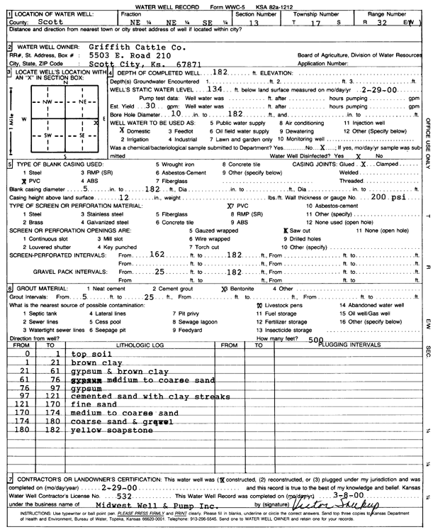
Specific Water Well Detail |
|
|
| Location Info | |||
| Owner: Griffith Cattle Co. | Status: Constructed | ||
| Location: T17S, R32W, Sec. 13, NE NE SE | County: Scott | ||
| Directions: | |||
| Latitude: 38.5764641 | Longitude: -100.7976011 | Datum NAD 27 | |
| Latitude: 38.5764809 | Longitude: -100.7980261 | Datum NAD 83 | |
| Longitude and latitude calculated by Survey from township-range-section-quarter calls. Only good to within the quarter call accuracy. | |||
| View well on interactive map | |||
| General Info | ||
| Well Depth: 182 ft. | Elevation: ft. | |
| Static Water Level: 134 ft. | Est. Yield: 30 gpm. | |
| Comp. Date: 29-Feb-2000 | Well Use: Domestic | |
| DWR Applic. #: | Other ID: | |
| Driller Info | ||
| Driller: Midwest Well & Pump, Inc. | License #: 532 | |
| Scanned Form | View scan |
|
Chemical Sample Submitted?:
Water Well disinfected?: | ||
| Casing Info | ||
| Casing Type:
Casing Joints: |
Diam: in. to ft | |
| Casing height above land surface: in
Casing Weight: lbs/ft Wall thickness or gauge no.: | ||
| Screen and Perforation Info | ||
| Screen Type: | Screen Openings: | |
| Screen-perforated intervals | From: ft to ft | |
| Gravel pack intervals | From: ft to ft | |
| Grout Info | ||
| Grout used: | From: to ft | |
| Source of Possible Contamination | ||
| Source: | ||
| Direction from well: | Distance: ft | |
| Lithologic Log
(Log data entered by KGS.) | ||
| From: 0 ft. to 1 ft. | top soil | |
| From: 1 ft. to 21 ft. | brown clay | |
| From: 21 ft. to 61 ft. | gypsum and brown clay | |
| From: 61 ft. to 76 ft. | medium to coarse sand | |
| From: 76 ft. to 97 ft. | gypsum | |
| From: 97 ft. to 121 ft. | cemented sand with clay streaks | |
| From: 121 ft. to 170 ft. | fine sand | |
| From: 170 ft. to 174 ft. | medium to coarse sand | |
| From: 174 ft. to 180 ft. | coarse sand and gravel | |
| From: 180 ft. to 182 ft. | yellow soapstone | |