|
|
|
Specific Water Well Detail |
|
|
| Location Info | |||
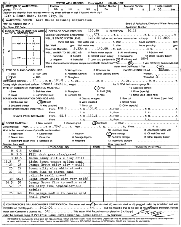
| Owner: Kerr-McGee Refining Corp | Status: Constructed | ||
| Location: T18S, R33W, Sec. 24, SE SE NE | County: Scott | ||
| Directions: 12th and S Main, Scott City | |||
| Latitude: 38.4760904 | Longitude: -100.9076319 | Datum NAD 27 | |
| Latitude: 38.4761098 | Longitude: -100.9080603 | Datum NAD 83 | |
| Longitude and latitude calculated by Survey from township-range-section-quarter calls. Only good to within the quarter call accuracy. | |||
| View well on interactive map | |||
| General Info | ||
| Well Depth: 130.8 ft. | Elevation: ft. | |
| Static Water Level: 120.18 ft. | Est. Yield: gpm. | |
| Comp. Date: 12-Jan-2000 | Well Use: Monitoring well/observation/piezometer | |
| DWR Applic. #: | Other ID: MW 1 | |
| Driller Info | ||
| Driller: Prairie Land Environmental Remed. | License #: 540 | |
| Scanned Form | View scan |
|
Chemical Sample Submitted?:
Water Well disinfected?: | ||
| Casing Info | ||
| Casing Type:
Casing Joints: |
Diam: in. to ft | |
| Casing height above land surface: in
Casing Weight: lbs/ft Wall thickness or gauge no.: | ||
| Screen and Perforation Info | ||
| Screen Type: | Screen Openings: | |
| Screen-perforated intervals | From: ft to ft | |
| Gravel pack intervals | From: ft to ft | |
| Grout Info | ||
| Grout used: | From: to ft | |
| Source of Possible Contamination | ||
| Source: | ||
| Direction from well: | Distance: ft | |
| Lithologic Log
(Log data entered by KGS.) | ||
| From: 0 ft. to .5 ft. | asphalt | |
| From: .5 ft. to 5.3 ft. | fill, dark gray clay/gravel | |
| From: 5.3 ft. to 18.5 ft. | brown sandy silt and c clay stiff | |
| From: 18.5 ft. to 23 ft. | light brown orange medium sand | |
| From: 23 ft. to 25 ft. | orange brown silty clay - stiff | |
| From: 25 ft. to 27 ft. | brown silty clay white streaks | |
| From: 27 ft. to 39 ft. | brown fine to coarse sand caliche small gravel | |
| From: 39 ft. to 56.5 ft. | light brown silty clay very stiff | |
| From: 56.5 ft. to 57 ft. | orange brown fine to medium sand | |
| From: 57 ft. to 75 ft. | tan silty fine sand calcareous nodules | |
| From: 75 ft. to 140 ft. | tan orange medium to coarse sand, small gravel | |