|
|
|
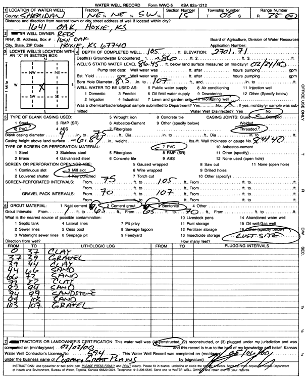
Specific Water Well Detail |
|
|
| Location Info | |||
| Owner: Red's | Status: Constructed | ||
| Location: T8S, R28W, Sec. 15, NE NE SW | County: Sheridan | ||
| Directions: 1641 Oak, hoxie | |||
| Latitude: 39.3568315 | Longitude: -100.433488 | Datum NAD 27 | |
| Latitude: 39.3568363 | Longitude: -100.4339059 | Datum NAD 83 | |
| Longitude and latitude calculated by Survey from township-range-section-quarter calls. Only good to within the quarter call accuracy. | |||
| View well on interactive map | |||
| General Info | ||
| Well Depth: 105 ft. | Elevation: 2701.71 ft. | |
| Static Water Level: 86.45 ft. | Est. Yield: gpm. | |
| Comp. Date: 02-Feb-2000 | Well Use: Monitoring well/observation/piezometer | |
| DWR Applic. #: | Other ID: MW 6 | |
| Driller Info | ||
| Driller: Coranco Great Plains, Inc. | License #: 594 | |
| Scanned Form | View scan |
|
Chemical Sample Submitted?:
Water Well disinfected?: | ||
| Casing Info | ||
| Casing Type:
Casing Joints: |
Diam: in. to ft | |
| Casing height above land surface: in
Casing Weight: lbs/ft Wall thickness or gauge no.: | ||
| Screen and Perforation Info | ||
| Screen Type: | Screen Openings: | |
| Screen-perforated intervals | From: ft to ft | |
| Gravel pack intervals | From: ft to ft | |
| Grout Info | ||
| Grout used: | From: to ft | |
| Source of Possible Contamination | ||
| Source: | ||
| Direction from well: | Distance: ft | |
| Lithologic Log
(Log data entered by KGS.) | ||
| From: 0 ft. to 37 ft. | Clay | |
| From: 37 ft. to 39 ft. | Gravel | |
| From: 39 ft. to 44 ft. | Clay | |
| From: 44 ft. to 66 ft. | Sand | |
| From: 66 ft. to 72 ft. | Sand | |
| From: 72 ft. to 82 ft. | Clay | |
| From: 82 ft. to 94 ft. | Sand | |
| From: 94 ft. to 99 ft. | Sandstone | |
| From: 99 ft. to 103 ft. | Sand | |
| From: 103 ft. to 107 ft. | Gravel | |