|
|
|
Specific Water Well Detail |
|
|
| Location Info | |||
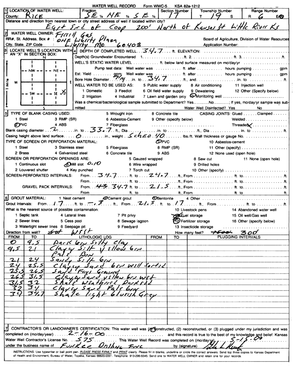
| Owner: Ferrell Gas | Status: Constructed | ||
| Location: T19S, R6W, Sec. 17, SE NE SE | County: Rice | ||
| Directions: E end of coop, 200' N of Kansas St, Little River | |||
| Latitude: 38.3958297 | Longitude: -97.9990709 | Datum NAD 27 | |
| Latitude: 38.3958393 | Longitude: -97.9994005 | Datum NAD 83 | |
| Longitude and latitude calculated by Survey from township-range-section-quarter calls. Only good to within the quarter call accuracy. | |||
| View well on interactive map | |||
| General Info | ||
| Well Depth: 34.7 ft. | Elevation: ft. | |
| Static Water Level: ft. | Est. Yield: gpm. | |
| Comp. Date: 16-Feb-2000 | Well Use: Monitoring well/observation/piezometer | |
| DWR Applic. #: | Other ID: MW 10 | |
| Driller Info | ||
| Driller: Funkee Drilling Service | License #: 575 | |
| Scanned Form | View scan |
|
Chemical Sample Submitted?:
Water Well disinfected?: | ||
| Casing Info | ||
| Casing Type:
Casing Joints: |
Diam: in. to ft | |
| Casing height above land surface: in
Casing Weight: lbs/ft Wall thickness or gauge no.: | ||
| Screen and Perforation Info | ||
| Screen Type: | Screen Openings: | |
| Screen-perforated intervals | From: ft to ft | |
| Gravel pack intervals | From: ft to ft | |
| Grout Info | ||
| Grout used: | From: to ft | |
| Source of Possible Contamination | ||
| Source: | ||
| Direction from well: | Distance: ft | |
| Lithologic Log
(Log data entered by KGS.) | ||
| From: 0 ft. to 9.5 ft. | dark brown silty clay | |
| From: 9.5 ft. to 21 ft. | clayey silt, yellow green, pale brown | |
| From: 21 ft. to 24 ft. | sandy silt, green | |
| From: 24 ft. to 25.5 ft. | clayey sand, brown, well sorted | |
| From: 25.5 ft. to 26.5 ft. | fine sand | |
| From: 26.5 ft. to 31.5 ft. | clayey sand, yellow brown, wet | |
| From: 31.5 ft. to 32 ft. | weathered shale, dark red | |
| From: 32 ft. to 34 ft. | clayey sand, pale brown | |
| From: 34 ft. to 34.7 ft. | shale, light bluish gray | |