|
|
|
Specific Water Well Detail |
|
|
| Location Info | |||
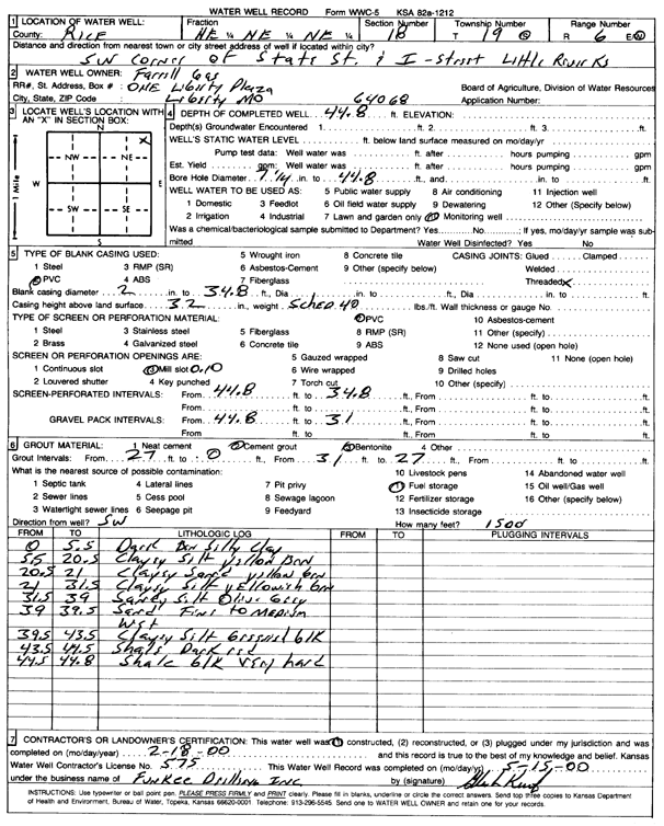
| Owner: Ferrell Gas | Status: Constructed | ||
| Location: T19S, R6W, Sec. 18, NE NE NE | County: Rice | ||
| Directions: SW corner of State St and I St, Little River (lat/long from const. report) | |||
| Latitude: 38.4048075 | Longitude: -98.0176902 | Datum NAD 27 | |
| Latitude: 38.4048162 | Longitude: -98.01802 | Datum NAD 83 | |
| Longitude and latitude from GPS measurements. | |||
| GPS Latitude: 38.4048075 | GPS Longitude: -98.0176902 | Datum NAD27 | |
| View well on interactive map | |||
| General Info | ||
| Well Depth: 44.8 ft. | Elevation: ft. | |
| Static Water Level: ft. | Est. Yield: gpm. | |
| Comp. Date: 18-Feb-2000 | Well Use: Monitoring well/observation/piezometer | |
| DWR Applic. #: | Other ID: PW 1 | |
| Driller Info | ||
| Driller: Funkee Drilling Service | License #: 575 | |
| Scanned Form | View scan |
|
Chemical Sample Submitted?:
Water Well disinfected?: | ||
| Casing Info | ||
| Casing Type:
Casing Joints: |
Diam: in. to ft | |
| Casing height above land surface: in
Casing Weight: lbs/ft Wall thickness or gauge no.: | ||
| Screen and Perforation Info | ||
| Screen Type: | Screen Openings: | |
| Screen-perforated intervals | From: ft to ft | |
| Gravel pack intervals | From: ft to ft | |
| Grout Info | ||
| Grout used: | From: to ft | |
| Source of Possible Contamination | ||
| Source: | ||
| Direction from well: | Distance: ft | |
| Lithologic Log
(Log data entered by KGS.) | ||
| From: 0 ft. to 5.5 ft. | dark brown silty clay | |
| From: 5.5 ft. to 20.5 ft. | clayey silt, yellow brown | |
| From: 20.5 ft. to 21 ft. | clayey sand, yellow brown | |
| From: 21 ft. to 31.5 ft. | clayey silt, yellowish brown | |
| From: 31.5 ft. to 39 ft. | sandy silt, olive gray | |
| From: 39 ft. to 39.5 ft. | sand, fine to medium, wet | |
| From: 39.5 ft. to 43.5 ft. | clayey silt, grayish black | |
| From: 43.5 ft. to 44.5 ft. | shale, dark red | |
| From: 44.5 ft. to 44.8 ft. | shale, black, very hard | |