|
|
|
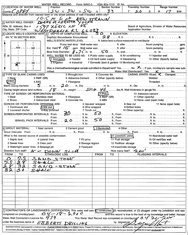
Specific Water Well Detail |
|
|
| Location Info | |||
| Owner: Young, Duane and Loretta | Status: Constructed | ||
| Location: T20S, R17E, Sec. 33, SW SW SW | County: Coffey | ||
| Directions: from New Strawn: 10.5 mi E | |||
| Latitude: 38.260267 | Longitude: -95.5431392 | Datum NAD 27 | |
| Latitude: 38.2602874 | Longitude: -95.5434004 | Datum NAD 83 | |
| Longitude and latitude calculated by Survey from township-range-section-quarter calls. Only good to within the quarter call accuracy. | |||
| View well on interactive map | |||
| General Info | ||
| Well Depth: 50 ft. | Elevation: ft. | |
| Static Water Level: ft. | Est. Yield: 15 gpm. | |
| Comp. Date: 18-Apr-2000 | Well Use: Domestic | |
| DWR Applic. #: | Other ID: | |
| Driller Info | ||
| Driller: Grogan Ebberts Drilling | License #: 479 | |
| Scanned Form | View scan |
|
Chemical Sample Submitted?:
Water Well disinfected?: | ||
| Casing Info | ||
| Casing Type:
Casing Joints: |
Diam: in. to ft | |
| Casing height above land surface: in
Casing Weight: lbs/ft Wall thickness or gauge no.: | ||
| Screen and Perforation Info | ||
| Screen Type: | Screen Openings: | |
| Screen-perforated intervals | From: ft to ft | |
| Gravel pack intervals | From: ft to ft | |
| Grout Info | ||
| Grout used: | From: to ft | |
| Source of Possible Contamination | ||
| Source: | ||
| Direction from well: | Distance: ft | |
| Lithologic Log
(Log data entered by KGS.) | ||
| From: 0 ft. to 7.5 ft. | sandstone | |
| From: 7.5 ft. to 28 ft. | shale | |
| From: 28 ft. to 32 ft. | sandstone | |
| From: 32 ft. to 50 ft. | shale | |