|
|
|
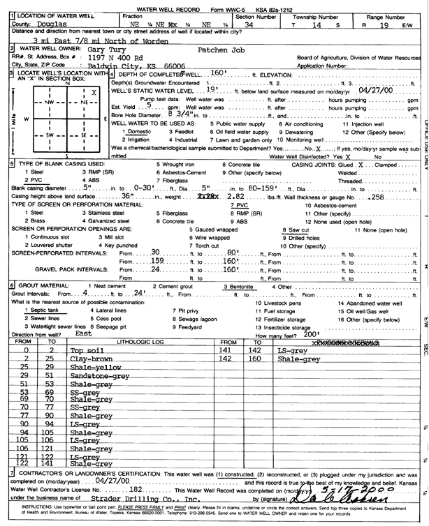
Specific Water Well Detail |
|
|
| Location Info | |||
| Owner: Tury, Gary | Status: Constructed | ||
| Location: T14S, R19E, Sec. 34, NE NENE | County: Douglas | ||
| Directions: from Worden, 3 mi E, .89 mi N | |||
| Latitude: 38.7960459 | Longitude: -95.2799235 | Datum NAD 27 | |
| Latitude: 38.796052 | Longitude: -95.280175 | Datum NAD 83 | |
| Longitude and latitude calculated by Survey from township-range-section-quarter calls. Only good to within the quarter call accuracy. | |||
| View well on interactive map | |||
| General Info | ||
| Well Depth: 160 ft. | Elevation: ft. | |
| Static Water Level: 19 ft. | Est. Yield: gpm. | |
| Comp. Date: 27-Apr-2000 | Well Use: Domestic | |
| DWR Applic. #: | Other ID: | |
| Driller Info | ||
| Driller: Strader Drilling Co., Inc. | License #: 182 | |
| Scanned Form | View scan |
|
Chemical Sample Submitted?:
Water Well disinfected?: | ||
| Casing Info | ||
| Casing Type:
Casing Joints: |
Diam: in. to ft | |
| Casing height above land surface: in
Casing Weight: lbs/ft Wall thickness or gauge no.: | ||
| Screen and Perforation Info | ||
| Screen Type: | Screen Openings: | |
| Screen-perforated intervals | From: ft to ft | |
| Gravel pack intervals | From: ft to ft | |
| Grout Info | ||
| Grout used: | From: to ft | |
| Source of Possible Contamination | ||
| Source: | ||
| Direction from well: | Distance: ft | |
| Lithologic Log
(Log data entered by KGS.) | ||
| From: 0 ft. to 2 ft. | top soil | |
| From: 2 ft. to 25 ft. | clay, brown | |
| From: 25 ft. to 29 ft. | shale, yellow | |
| From: 29 ft. to 51 ft. | sandstone, gray | |
| From: 51 ft. to 53 ft. | shale, gray | |
| From: 53 ft. to 69 ft. | sandstone, gray | |
| From: 69 ft. to 70 ft. | shale, gray | |
| From: 70 ft. to 77 ft. | sandstone, gray | |
| From: 77 ft. to 90 ft. | shale, gray | |
| From: 90 ft. to 94 ft. | limestone, gray | |
| From: 94 ft. to 105 ft. | shale, gray | |
| From: 105 ft. to 106 ft. | limestone, gray | |
| From: 106 ft. to 121 ft. | shale, gray | |
| From: 121 ft. to 122 ft. | limestone, gray | |
| From: 122 ft. to 141 ft. | shale, gray | |
| From: 141 ft. to 142 ft. | limestone, gray | |
| From: 142 ft. to 160 ft. | shale, gray | |