|
|
|
Specific Water Well Detail |
|
|
| Location Info | |||
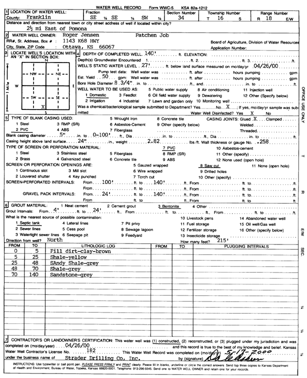
| Owner: Jensen, Roger | Status: Constructed | ||
| Location: T16S, R18E, Sec. 34, SE SE SW | County: Franklin | ||
| Directions: from Pomona: 2.5 mi E | |||
| Latitude: 38.6093232 | Longitude: -95.4075631 | Datum NAD 27 | |
| Latitude: 38.6093337 | Longitude: -95.4078186 | Datum NAD 83 | |
| Longitude and latitude calculated by Survey from township-range-section-quarter calls. Only good to within the quarter call accuracy. | |||
| View well on interactive map | |||
| General Info | ||
| Well Depth: 140 ft. | Elevation: ft. | |
| Static Water Level: 27 ft. | Est. Yield: 50 gpm. | |
| Comp. Date: 26-Apr-2000 | Well Use: Domestic | |
| DWR Applic. #: | Other ID: | |
| Driller Info | ||
| Driller: Strader Drilling Co., Inc. | License #: 182 | |
| Scanned Form | View scan |
|
Chemical Sample Submitted?:
Water Well disinfected?: | ||
| Casing Info | ||
| Casing Type:
Casing Joints: |
Diam: in. to ft | |
| Casing height above land surface: in
Casing Weight: lbs/ft Wall thickness or gauge no.: | ||
| Screen and Perforation Info | ||
| Screen Type: | Screen Openings: | |
| Screen-perforated intervals | From: ft to ft | |
| Gravel pack intervals | From: ft to ft | |
| Grout Info | ||
| Grout used: | From: to ft | |
| Source of Possible Contamination | ||
| Source: | ||
| Direction from well: | Distance: ft | |
| Lithologic Log
(Log data entered by KGS.) | ||
| From: 0 ft. to 5 ft. | Fill dirt, clay, brown | |
| From: 5 ft. to 25 ft. | Shale, yellow | |
| From: 25 ft. to 48 ft. | Sandy shale, gray | |
| From: 48 ft. to 70 ft. | Shale, gray | |
| From: 70 ft. to 140 ft. | Sandstone, gray | |