|
|
|
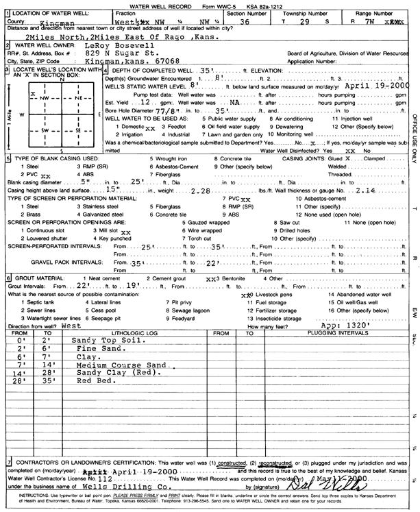
Specific Water Well Detail |
|
|
| Location Info | |||
| Owner: Bosewell, LeRoy | Status: Reconstructed | ||
| Location: T29S, R7W, Sec. 36, W2 NW NW | County: Kingman | ||
| Directions: from Rago: 2 mi N, 2 mi E | |||
| Latitude: 37.48496 | Longitude: -98.0436856 | Datum NAD 27 | |
| Latitude: 37.4849769 | Longitude: -98.0440241 | Datum NAD 83 | |
| Longitude and latitude calculated by Survey from township-range-section-quarter calls. Only good to within the quarter call accuracy. | |||
| View well on interactive map | |||
| General Info | ||
| Well Depth: 35 ft. | Elevation: ft. | |
| Static Water Level: 8 ft. | Est. Yield: 12 gpm. | |
| Comp. Date: 19-Apr-2000 | Well Use: Domestic | |
| DWR Applic. #: | Other ID: | |
| Driller Info | ||
| Driller: Dal Wells Drilling Co. | License #: 112 | |
| Scanned Form | View scan |
|
Chemical Sample Submitted?:
Water Well disinfected?: | ||
| Casing Info | ||
| Casing Type:
Casing Joints: |
Diam: in. to ft | |
| Casing height above land surface: in
Casing Weight: lbs/ft Wall thickness or gauge no.: | ||
| Screen and Perforation Info | ||
| Screen Type: | Screen Openings: | |
| Screen-perforated intervals | From: ft to ft | |
| Gravel pack intervals | From: ft to ft | |
| Grout Info | ||
| Grout used: | From: to ft | |
| Source of Possible Contamination | ||
| Source: | ||
| Direction from well: | Distance: ft | |