|
|
|
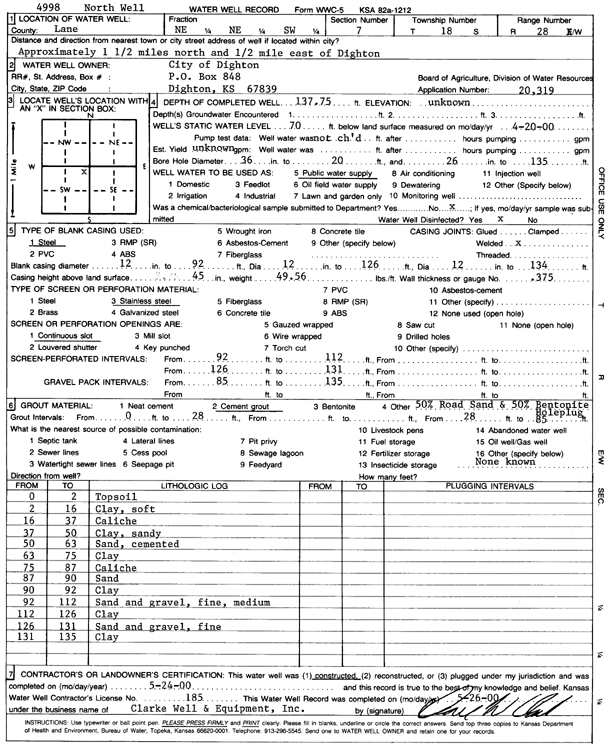
Specific Water Well Detail |
|
|
| Location Info | |||
| Owner: City of Dighton | Status: Constructed | ||
| Location: T18S, R28W, Sec. 7, NE NE SW | County: Lane | ||
| Directions: from Dighton: 1.5 mi N and 0.5 mi E | |||
| Latitude: 38.5029364 | Longitude: -100.4590459 | Datum NAD 27 | |
| Latitude: 38.502953 | Longitude: -100.4594631 | Datum NAD 83 | |
| Longitude and latitude calculated by Survey from township-range-section-quarter calls. Only good to within the quarter call accuracy. | |||
| View well on interactive map | |||
| General Info | ||
| Well Depth: 137.75 ft. | Elevation: ft. | |
| Static Water Level: 70 ft. | Est. Yield: gpm. | |
| Comp. Date: 24-May-2000 | Well Use: Public Water Supply | |
| DWR Applic. #: 20319 | Other ID: N Well | |
| Links | |
| No Wizard information available. | |
| View info from WIMAS Water Right Data base... | |
| Driller Info | ||
| Driller: Clarke Well and Equipment, Inc. | License #: 185 | |
| Scanned Form | View scan |
|
Chemical Sample Submitted?:
Water Well disinfected?: | ||
| Casing Info | ||
| Casing Type:
Casing Joints: |
Diam: in. to ft | |
| Casing height above land surface: in
Casing Weight: lbs/ft Wall thickness or gauge no.: | ||
| Screen and Perforation Info | ||
| Screen Type: | Screen Openings: | |
| Screen-perforated intervals | From: ft to ft | |
| Gravel pack intervals | From: ft to ft | |
| Grout Info | ||
| Grout used: | From: to ft | |
| Source of Possible Contamination | ||
| Source: | ||
| Direction from well: | Distance: ft | |
| Lithologic Log
(Log data entered by KGS.) | ||
| From: 0 ft. to 2 ft. | Top soil | |
| From: 2 ft. to 16 ft. | Clay, soft | |
| From: 16 ft. to 37 ft. | Caliche | |
| From: 37 ft. to 50 ft. | Clay, sandy | |
| From: 50 ft. to 63 ft. | Sand, cemented | |
| From: 63 ft. to 75 ft. | Clay | |
| From: 75 ft. to 87 ft. | Caliche | |
| From: 87 ft. to 90 ft. | Sand | |
| From: 90 ft. to 92 ft. | Clay | |
| From: 92 ft. to 112 ft. | Sand and gravel, fine, medium | |
| From: 112 ft. to 126 ft. | Clay | |
| From: 126 ft. to 131 ft. | Sand and gravel, fine | |
| From: 131 ft. to 135 ft. | Clay | |