|
|
|
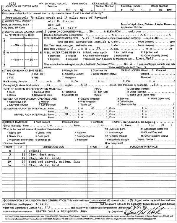
Specific Water Well Detail |
|
|
| Location Info | |||
| Owner: Sleeper, Alan R. | Status: Constructed | ||
| Location: T22S, R10W, Sec. 5, C N2 | County: Reno | ||
| Directions: from Raymond: 7.25 mi S, 1.5 mi W | |||
| Latitude: 38.1693575 | Longitude: -98.4450741 | Datum NAD 27 | |
| Latitude: 38.1693703 | Longitude: -98.445425 | Datum NAD 83 | |
| Longitude and latitude calculated by Survey from township-range-section-quarter calls. Only good to within the quarter call accuracy. | |||
| View well on interactive map | |||
| General Info | ||
| Well Depth: 36 ft. | Elevation: ft. | |
| Static Water Level: 5.79 ft. | Est. Yield: gpm. | |
| Comp. Date: 14-Jun-2000 | Well Use: Domestic, Livestock | |
| DWR Applic. #: | Other ID: | |
| Driller Info | ||
| Driller: Clarke Well and Equipment, Inc. | License #: 185 | |
| Scanned Form | View scan |
|
Chemical Sample Submitted?:
Water Well disinfected?: | ||
| Casing Info | ||
| Casing Type:
Casing Joints: |
Diam: in. to ft | |
| Casing height above land surface: in
Casing Weight: lbs/ft Wall thickness or gauge no.: | ||
| Screen and Perforation Info | ||
| Screen Type: | Screen Openings: | |
| Screen-perforated intervals | From: ft to ft | |
| Gravel pack intervals | From: ft to ft | |
| Grout Info | ||
| Grout used: | From: to ft | |
| Source of Possible Contamination | ||
| Source: | ||
| Direction from well: | Distance: ft | |
| Lithologic Log
(Log data entered by KGS.) | ||
| From: 0 ft. to 5 ft. | top soil | |
| From: 5 ft. to 11 ft. | clay, dark gray | |
| From: 11 ft. to 19 ft. | clay, white, sandy | |
| From: 19 ft. to 34 ft. | sand and gravel, medium, fine | |
| From: 34 ft. to 35 ft. | clay, white, hard | |