|
|
|
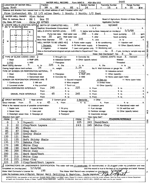
Specific Water Well Detail |
|
|
| Location Info | |||
| Owner: Maier, Alan | Status: Constructed | ||
| Location: T16S, R16W, Sec. 24, NW NW NE | County: Rush | ||
| Directions: from Liebenthal: 12.5 mi E, 1 mi S, 1 mi N, .5 mi E | |||
| Latitude: 38.6519138 | Longitude: -99.0406859 | Datum NAD 27 | |
| Latitude: 38.6519261 | Longitude: -99.0410574 | Datum NAD 83 | |
| Longitude and latitude calculated by Survey from township-range-section-quarter calls. Only good to within the quarter call accuracy. | |||
| View well on interactive map | |||
| General Info | ||
| Well Depth: 245 ft. | Elevation: ft. | |
| Static Water Level: 145 ft. | Est. Yield: 20 gpm. | |
| Comp. Date: 19-May-2000 | Well Use: Domestic | |
| DWR Applic. #: | Other ID: | |
| Driller Info | ||
| Driller: Karst Water Well Drilling & Service, Inc. | License #: 199 | |
| Scanned Form | View scan |
|
Chemical Sample Submitted?:
Water Well disinfected?: | ||
| Casing Info | ||
| Casing Type:
Casing Joints: |
Diam: in. to ft | |
| Casing height above land surface: in
Casing Weight: lbs/ft Wall thickness or gauge no.: | ||
| Screen and Perforation Info | ||
| Screen Type: | Screen Openings: | |
| Screen-perforated intervals | From: ft to ft | |
| Gravel pack intervals | From: ft to ft | |
| Grout Info | ||
| Grout used: | From: to ft | |
| Source of Possible Contamination | ||
| Source: | ||
| Direction from well: | Distance: ft | |
| Lithologic Log
(Log data entered by KGS.) | ||
| From: 0 ft. to 3 ft. | topsoil | |
| From: 3 ft. to 22 ft. | clay/rock layer | |
| From: 22 ft. to 85 ft. | shale | |
| From: 85 ft. to 87 ft. | gray rock | |
| From: 87 ft. to 120 ft. | grainy shale | |
| From: 120 ft. to 121 ft. | rock | |
| From: 121 ft. to 135 ft. | soft sticky shale | |
| From: 135 ft. to 173 ft. | Dakota clay | |
| From: 173 ft. to 188 ft. | white clay | |
| From: 188 ft. to 190 ft. | hard sand/rock | |
| From: 190 ft. to 200 ft. | white clay | |
| From: 200 ft. to 201 ft. | hard sand/rock | |
| From: 201 ft. to 210 ft. | white clay | |
| From: 210 ft. to 223 ft. | gray clay | |
| From: 223 ft. to 225 ft. | clay/sand/rock layers | |