|
|
|
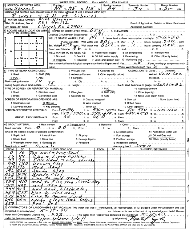
Specific Water Well Detail |
|
|
| Location Info | |||
| Owner: Hatcher, Nick | Status: Constructed | ||
| Location: T34S, R35W, Sec. 24, NE NE NE | County: Stevens | ||
| Directions: from Liberal, 8 mi W and 2 mi N | |||
| Latitude: 37.0820266 | Longitude: -101.0679021 | Datum NAD 27 | |
| Latitude: 37.0820523 | Longitude: -101.0683455 | Datum NAD 83 | |
| Longitude and latitude calculated by Survey from township-range-section-quarter calls. Only good to within the quarter call accuracy. | |||
| View well on interactive map | |||
| General Info | ||
| Well Depth: 650 ft. | Elevation: ft. | |
| Static Water Level: 191 ft. | Est. Yield: 2000 gpm. | |
| Comp. Date: 15-May-2000 | Well Use: Irrigation | |
| DWR Applic. #: | Other ID: | |
| Links | |
| No Wizard information available. | |
| View info from WIMAS Water Right Data base... | |
| Driller Info | ||
| Driller: Destal Tyler Water Well Service | License #: 473 | |
| Scanned Form | View scan |
|
Chemical Sample Submitted?:
Water Well disinfected?: | ||
| Casing Info | ||
| Casing Type:
Casing Joints: |
Diam: in. to ft | |
| Casing height above land surface: in
Casing Weight: lbs/ft Wall thickness or gauge no.: | ||
| Screen and Perforation Info | ||
| Screen Type: | Screen Openings: | |
| Screen-perforated intervals | From: ft to ft | |
| Gravel pack intervals | From: ft to ft | |
| Grout Info | ||
| Grout used: | From: to ft | |
| Source of Possible Contamination | ||
| Source: | ||
| Direction from well: | Distance: ft | |
| Lithologic Log
(Log data entered by KGS.) | ||
| From: 0 ft. to 16 ft. | top soil and fine sand | |
| From: 16 ft. to 49 ft. | clay and little caliche | |
| From: 49 ft. to 90 ft. | fine sand and clay streaks | |
| From: 90 ft. to 180 ft. | brown clay | |
| From: 180 ft. to 196 ft. | medium sand | |
| From: 196 ft. to 262 ft. | sandy clay | |
| From: 262 ft. to 279 ft. | brown clay | |
| From: 279 ft. to 328 ft. | fine to medium sand | |
| From: 328 ft. to 410 ft. | med to fine sand, little clay | |
| From: 410 ft. to 444 ft. | medium sand | |
| From: 444 ft. to 459 ft. | medium sand, little clay | |
| From: 459 ft. to 575 ft. | fine to medium sand | |
| From: 575 ft. to 640 ft. | fine to coarse sand | |
| From: 640 ft. to 650 ft. | sandy clay and rock ledges | |
| From: 650 ft. to ft. | red bed | |