|
|
|
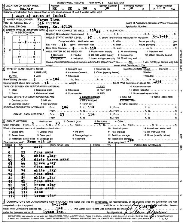
Specific Water Well Detail |
|
|
| Location Info | |||
| Owner: Thom, Wayne | Status: Constructed | ||
| Location: T30S, R11W, Sec. 30, NE SE NW | County: Barber | ||
| Directions: from Isabel, 0.5 mi W, 4.5 mi S | |||
| Latitude: 37.4084617 | Longitude: -98.5660139 | Datum NAD 27 | |
| Latitude: 37.4084824 | Longitude: -98.5663752 | Datum NAD 83 | |
| Longitude and latitude calculated by Survey from township-range-section-quarter calls. Only good to within the quarter call accuracy. | |||
| View well on interactive map | |||
| General Info | ||
| Well Depth: 114 ft. | Elevation: ft. | |
| Static Water Level: 67 ft. | Est. Yield: 10 gpm. | |
| Comp. Date: 13-May-2000 | Well Use: Domestic | |
| DWR Applic. #: | Other ID: | |
| Driller Info | ||
| Driller: Dean L. Lyman, Inc. | License #: 140 | |
| Scanned Form | View scan |
|
Chemical Sample Submitted?:
Water Well disinfected?: | ||
| Casing Info | ||
| Casing Type:
Casing Joints: |
Diam: in. to ft | |
| Casing height above land surface: in
Casing Weight: lbs/ft Wall thickness or gauge no.: | ||
| Screen and Perforation Info | ||
| Screen Type: | Screen Openings: | |
| Screen-perforated intervals | From: ft to ft | |
| Gravel pack intervals | From: ft to ft | |
| Grout Info | ||
| Grout used: | From: to ft | |
| Source of Possible Contamination | ||
| Source: | ||
| Direction from well: | Distance: ft | |
| Lithologic Log
(Log data entered by KGS.) | ||
| From: 0 ft. to 5 ft. | soil | |
| From: 5 ft. to 22 ft. | fine sand | |
| From: 22 ft. to 45 ft. | white clay | |
| From: 45 ft. to 58 ft. | dirty brown sand | |
| From: 58 ft. to 66 ft. | brown clay | |
| From: 66 ft. to 72 ft. | fine sand | |
| From: 72 ft. to 75 ft. | white clay | |
| From: 75 ft. to 82 ft. | fine sand | |
| From: 82 ft. to 85 ft. | white clay | |
| From: 85 ft. to 92 ft. | fine sand | |
| From: 92 ft. to 103 ft. | brown clay | |
| From: 103 ft. to 106 ft. | fine sand | |
| From: 106 ft. to 112 ft. | sand | |
| From: 112 ft. to 114 ft. | brown clay | |