|
|
|
Specific Water Well Detail |
|
|
| Location Info | |||
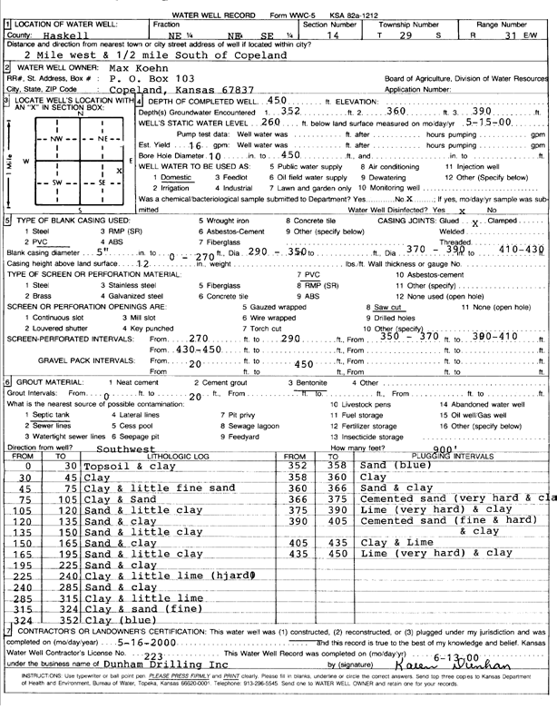
| Owner: Koehn, Max | Status: Constructed | ||
| Location: T29S, R31W, Sec. 14, NE NE SE | County: Haskell | ||
| Directions: from Copeland: 2 mi W, .5 mi S | |||
| Latitude: 37.5248168 | Longitude: -100.6715004 | Datum NAD 27 | |
| Latitude: 37.5248411 | Longitude: -100.6719352 | Datum NAD 83 | |
| Longitude and latitude calculated by Survey from township-range-section-quarter calls. Only good to within the quarter call accuracy. | |||
| View well on interactive map | |||
| General Info | ||
| Well Depth: 450 ft. | Elevation: ft. | |
| Static Water Level: 260 ft. | Est. Yield: 16 gpm. | |
| Comp. Date: 16-May-2000 | Well Use: Domestic | |
| DWR Applic. #: | Other ID: | |
| Driller Info | ||
| Driller: Donald R. Dunham Drilling, Inc. | License #: 223 | |
| Scanned Form | View scan |
|
Chemical Sample Submitted?:
Water Well disinfected?: | ||
| Casing Info | ||
| Casing Type:
Casing Joints: |
Diam: in. to ft | |
| Casing height above land surface: in
Casing Weight: lbs/ft Wall thickness or gauge no.: | ||
| Screen and Perforation Info | ||
| Screen Type: | Screen Openings: | |
| Screen-perforated intervals | From: ft to ft | |
| Gravel pack intervals | From: ft to ft | |
| Grout Info | ||
| Grout used: | From: to ft | |
| Source of Possible Contamination | ||
| Source: | ||
| Direction from well: | Distance: ft | |
| Lithologic Log
(Log data entered by KGS.) | ||
| From: 0 ft. to 30 ft. | topsoil and clay | |
| From: 30 ft. to 45 ft. | clay | |
| From: 45 ft. to 75 ft. | clay and little fine sand | |
| From: 75 ft. to 105 ft. | clay and sand | |
| From: 105 ft. to 120 ft. | sand and little clay | |
| From: 120 ft. to 135 ft. | sand and clay | |
| From: 135 ft. to 150 ft. | sand and little clay | |
| From: 150 ft. to 165 ft. | sand and clay | |
| From: 165 ft. to 195 ft. | sand and little clay | |
| From: 195 ft. to 225 ft. | sand and clay | |
| From: 225 ft. to 240 ft. | clay and little lime (hard) | |
| From: 240 ft. to 285 ft. | sand and clay | |
| From: 285 ft. to 315 ft. | clay and little lime | |
| From: 315 ft. to 324 ft. | clay and sand (fine) | |
| From: 324 ft. to 352 ft. | clay (blue) | |
| From: 352 ft. to 358 ft. | sand (blue) | |
| From: 358 ft. to 360 ft. | clay | |
| From: 360 ft. to 366 ft. | sand and clay | |
| From: 366 ft. to 375 ft. | cemented sand (very hard) and clay | |
| From: 375 ft. to 390 ft. | lime (very hard) and clay | |
| From: 390 ft. to 405 ft. | cemented sand (fine and hard) and clay | |
| From: 405 ft. to 435 ft. | clay and lime | |
| From: 435 ft. to 450 ft. | lime (very hard) and clay | |