|
|
|
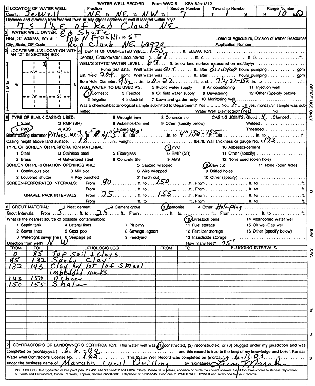
Specific Water Well Detail |
|
|
| Location Info | |||
| Owner: Shute, Ed | Status: Constructed | ||
| Location: T1S, R10W, Sec. 7, NE NE NW | County: Jewell | ||
| Directions: from Red Cloud, NE, 7 mi S and 1.5 mi E | |||
| Latitude: 39.9868283 | Longitude: -98.496217 | Datum NAD 27 | |
| Latitude: 39.9868418 | Longitude: -98.4965533 | Datum NAD 83 | |
| Longitude and latitude calculated by Survey from township-range-section-quarter calls. Only good to within the quarter call accuracy. | |||
| View well on interactive map | |||
| General Info | ||
| Well Depth: 155 ft. | Elevation: ft. | |
| Static Water Level: 67 ft. | Est. Yield: 20 gpm. | |
| Comp. Date: 06-Jun-2000 | Well Use: Domestic | |
| DWR Applic. #: | Other ID: | |
| Driller Info | ||
| Driller: Leroy Maruhn Well Drilling, Inc. | License #: 165 | |
| Scanned Form | View scan |
|
Chemical Sample Submitted?:
Water Well disinfected?: | ||
| Casing Info | ||
| Casing Type:
Casing Joints: |
Diam: in. to ft | |
| Casing height above land surface: in
Casing Weight: lbs/ft Wall thickness or gauge no.: | ||
| Screen and Perforation Info | ||
| Screen Type: | Screen Openings: | |
| Screen-perforated intervals | From: ft to ft | |
| Gravel pack intervals | From: ft to ft | |
| Grout Info | ||
| Grout used: | From: to ft | |
| Source of Possible Contamination | ||
| Source: | ||
| Direction from well: | Distance: ft | |
| Lithologic Log
(Log data entered by KGS.) | ||
| From: 0 ft. to 85 ft. | top soil and clays | |
| From: 85 ft. to 132 ft. | sandy clay | |
| From: 132 ft. to 143 ft. | clay with lots of small embedded rocks | |
| From: 143 ft. to 150 ft. | ochre | |
| From: 150 ft. to 155 ft. | shale | |