|
|
|
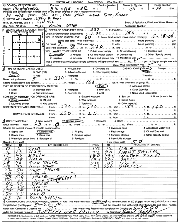
Specific Water Well Detail |
|
|
| Location Info | |||
| Owner: Davis, Jeffrey A. | Status: Constructed | ||
| Location: T35S, R14E, Sec. 1, SE NE NE | County: Montgomery | ||
| Directions: from 166, Tyro: .25 mi on Road 2700 | |||
| Latitude: 37.0345364 | Longitude: -95.8206481 | Datum NAD 27 | |
| Latitude: 37.0346119 | Longitude: -95.8209056 | Datum NAD 83 | |
| Longitude and latitude calculated by Survey from township-range-section-quarter calls. Only good to within the quarter call accuracy. | |||
| View well on interactive map | |||
| General Info | ||
| Well Depth: 220 ft. | Elevation: ft. | |
| Static Water Level: 60 ft. | Est. Yield: 2 gpm. | |
| Comp. Date: 23-May-2000 | Well Use: Domestic | |
| DWR Applic. #: | Other ID: | |
| Driller Info | ||
| Driller: Jeffrey Well Drilling | License #: 512 | |
| Scanned Form | View scan |
|
Chemical Sample Submitted?:
Water Well disinfected?: | ||
| Casing Info | ||
| Casing Type:
Casing Joints: |
Diam: in. to ft | |
| Casing height above land surface: in
Casing Weight: lbs/ft Wall thickness or gauge no.: | ||
| Screen and Perforation Info | ||
| Screen Type: | Screen Openings: | |
| Screen-perforated intervals | From: ft to ft | |
| Gravel pack intervals | From: ft to ft | |
| Grout Info | ||
| Grout used: | From: to ft | |
| Source of Possible Contamination | ||
| Source: | ||
| Direction from well: | Distance: ft | |
| Lithologic Log
(Log data entered by KGS.) | ||
| From: 0 ft. to 5 ft. | soil | |
| From: 5 ft. to 15 ft. | clay | |
| From: 15 ft. to 25 ft. | shale | |
| From: 25 ft. to 28 ft. | limestone | |
| From: 28 ft. to 40 ft. | sand and shale | |
| From: 40 ft. to 42 ft. | limestone and shale | |
| From: 42 ft. to 50 ft. | light shale | |
| From: 50 ft. to 55 ft. | limestone | |
| From: 55 ft. to 100 ft. | shale | |
| From: 100 ft. to 102 ft. | limestone | |
| From: 102 ft. to 135 ft. | shale | |
| From: 135 ft. to 138 ft. | limestone | |
| From: 138 ft. to 159 ft. | shale | |
| From: 159 ft. to 165 ft. | sand | |
| From: 165 ft. to 170 ft. | dark shale | |
| From: 170 ft. to 172 ft. | limestone | |
| From: 172 ft. to 180 ft. | light shale | |
| From: 180 ft. to 195 ft. | water sand | |
| From: 195 ft. to 200 ft. | shale | |
| From: 200 ft. to 203 ft. | limestone | |
| From: 203 ft. to 220 ft. | shale | |