|
|
|
Specific Water Well Detail |
|
|
| Location Info | |||
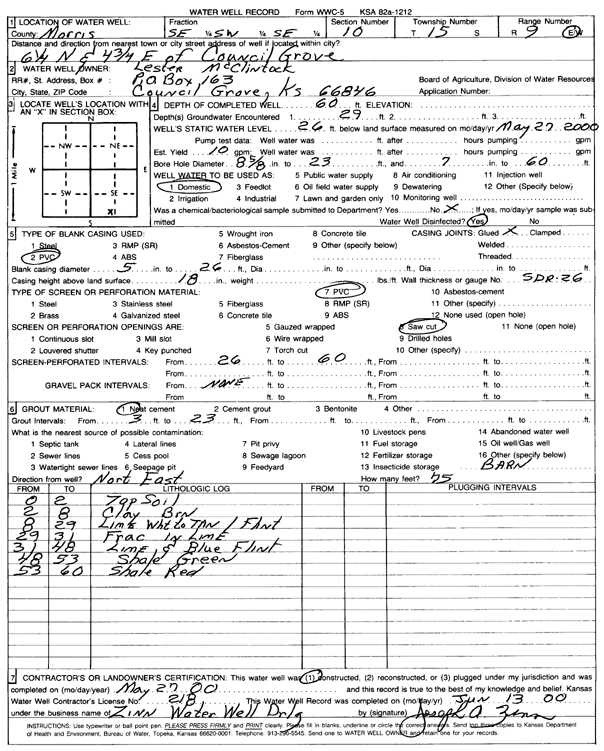
| Owner: McClintock, Lester | Status: Constructed | ||
| Location: T15S, R9E, Sec. 10, SE SW SE | County: Morris | ||
| Directions: from Council Grove: 6.25 mi N, 4.75 mi E | |||
| Latitude: 38.7545755 | Longitude: -96.3953114 | Datum NAD 27 | |
| Latitude: 38.7545565 | Longitude: -96.3955892 | Datum NAD 83 | |
| Longitude and latitude calculated by Survey from township-range-section-quarter calls. Only good to within the quarter call accuracy. | |||
| View well on interactive map | |||
| General Info | ||
| Well Depth: 60 ft. | Elevation: ft. | |
| Static Water Level: 26 ft. | Est. Yield: 10 gpm. | |
| Comp. Date: 27-May-2000 | Well Use: Domestic | |
| DWR Applic. #: | Other ID: | |
| Driller Info | ||
| Driller: Zinn Water Well Drlg. | License #: 218 | |
| Scanned Form | View scan |
|
Chemical Sample Submitted?:
Water Well disinfected?: | ||
| Casing Info | ||
| Casing Type:
Casing Joints: |
Diam: in. to ft | |
| Casing height above land surface: in
Casing Weight: lbs/ft Wall thickness or gauge no.: | ||
| Screen and Perforation Info | ||
| Screen Type: | Screen Openings: | |
| Screen-perforated intervals | From: ft to ft | |
| Gravel pack intervals | From: ft to ft | |
| Grout Info | ||
| Grout used: | From: to ft | |
| Source of Possible Contamination | ||
| Source: | ||
| Direction from well: | Distance: ft | |
| Lithologic Log
(Log data entered by KGS.) | ||
| From: 0 ft. to 2 ft. | top soil | |
| From: 2 ft. to 8 ft. | clay, brown | |
| From: 8 ft. to 29 ft. | limestone, white to tan, with flint | |
| From: 29 ft. to 31 ft. | fractured limestone | |
| From: 31 ft. to 48 ft. | limestone and blue flint | |
| From: 48 ft. to 53 ft. | shale, green | |
| From: 53 ft. to 60 ft. | shale, red | |