|
|
|
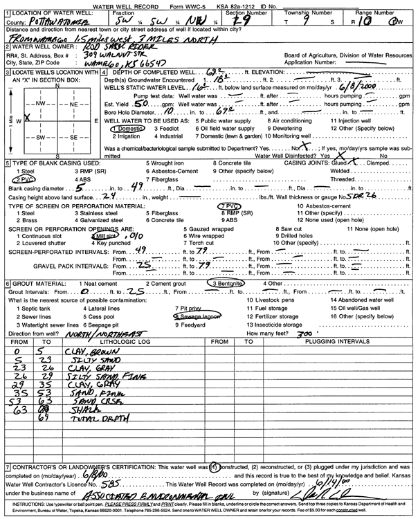
Specific Water Well Detail |
|
|
| Location Info | |||
| Owner: Sackrider, Rod | Status: Constructed | ||
| Location: T9S, R10E, Sec. 19, SW SW NW | County: Pottawatomie | ||
| Directions: from Wamego: 1.5 mi W, 3 mi N | |||
| Latitude: 39.254244 | Longitude: -96.3505502 | Datum NAD 27 | |
| Latitude: 39.2542402 | Longitude: -96.3508269 | Datum NAD 83 | |
| Longitude and latitude calculated by Survey from township-range-section-quarter calls. Only good to within the quarter call accuracy. | |||
| View well on interactive map | |||
| General Info | ||
| Well Depth: 69 ft. | Elevation: ft. | |
| Static Water Level: 16 ft. | Est. Yield: 50 gpm. | |
| Comp. Date: 08-Jun-2000 | Well Use: Domestic | |
| DWR Applic. #: | Other ID: | |
| Driller Info | ||
| Driller: Associated Environmental, Inc. | License #: 585 | |
| Scanned Form | View scan |
|
Chemical Sample Submitted?:
Water Well disinfected?: | ||
| Casing Info | ||
| Casing Type:
Casing Joints: |
Diam: in. to ft | |
| Casing height above land surface: in
Casing Weight: lbs/ft Wall thickness or gauge no.: | ||
| Screen and Perforation Info | ||
| Screen Type: | Screen Openings: | |
| Screen-perforated intervals | From: ft to ft | |
| Gravel pack intervals | From: ft to ft | |
| Grout Info | ||
| Grout used: | From: to ft | |
| Source of Possible Contamination | ||
| Source: | ||
| Direction from well: | Distance: ft | |
| Lithologic Log
(Log data entered by KGS.) | ||
| From: 0 ft. to 5 ft. | clay, brown | |
| From: 5 ft. to 23 ft. | silty sand | |
| From: 23 ft. to 26 ft. | clay, gray | |
| From: 26 ft. to 29 ft. | silty sand, fine | |
| From: 29 ft. to 35 ft. | clay, gray | |
| From: 35 ft. to 53 ft. | fine sand | |
| From: 53 ft. to 63 ft. | coarse sand | |
| From: 63 ft. to 69 ft. | shale | |