|
|
|
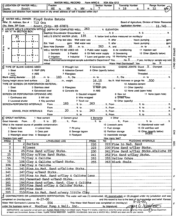
Specific Water Well Detail |
|
|
| Location Info | |||
| Owner: Floyd Krebs Estate | Status: Reconstructed | ||
| Location: T18S, R32W, Sec. 7, NE NW NW | County: Scott | ||
| Directions: | |||
| Latitude: 38.5105798 | Longitude: -100.9032441 | Datum NAD 27 | |
| Latitude: 38.5105985 | Longitude: -100.9036716 | Datum NAD 83 | |
| Longitude and latitude calculated by Survey from township-range-section-quarter calls. Only good to within the quarter call accuracy. | |||
| View well on interactive map | |||
| General Info | ||
| Well Depth: 263 ft. | Elevation: ft. | |
| Static Water Level: 135 ft. | Est. Yield: gpm. | |
| Comp. Date: 27-Apr-2000 | Well Use: Irrigation | |
| DWR Applic. #: 11745 | Other ID: | |
| Links | |
| No Wizard information available. | |
| View info from WIMAS Water Right Data base... | |
| Driller Info | ||
| Driller: Jay C. Woofter Pump & Well, Inc. | License #: 554 | |
| Scanned Form | View scan |
|
Chemical Sample Submitted?:
Water Well disinfected?: | ||
| Casing Info | ||
| Casing Type:
Casing Joints: |
Diam: in. to ft | |
| Casing height above land surface: in
Casing Weight: lbs/ft Wall thickness or gauge no.: | ||
| Screen and Perforation Info | ||
| Screen Type: | Screen Openings: | |
| Screen-perforated intervals | From: ft to ft | |
| Gravel pack intervals | From: ft to ft | |
| Grout Info | ||
| Grout used: | From: to ft | |
| Source of Possible Contamination | ||
| Source: | ||
| Direction from well: | Distance: ft | |