|
|
|
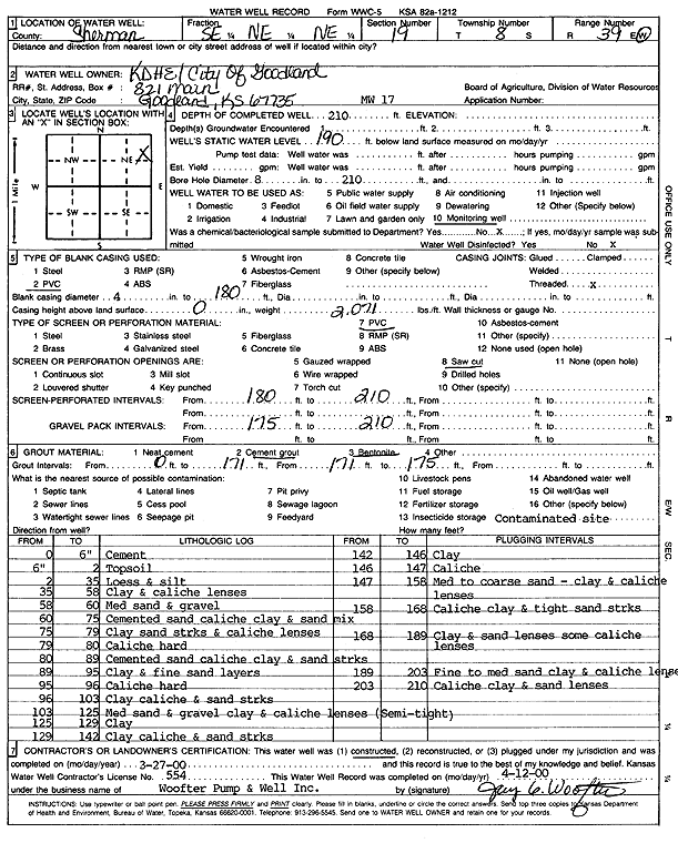
Specific Water Well Detail |
|
|
| Location Info | |||
| Owner: KDHE/City of Goodland | Status: Constructed | ||
| Location: T8S, R39W, Sec. 19, SE NE NE | County: Sherman | ||
| Directions: | |||
| Latitude: 39.3484863 | Longitude: -101.7081735 | Datum NAD 27 | |
| Latitude: 39.348486 | Longitude: -101.7086235 | Datum NAD 83 | |
| Longitude and latitude calculated by Survey from township-range-section-quarter calls. Only good to within the quarter call accuracy. | |||
| View well on interactive map | |||
| General Info | ||
| Well Depth: 210 ft. | Elevation: ft. | |
| Static Water Level: 190 ft. | Est. Yield: gpm. | |
| Comp. Date: 27-Mar-2000 | Well Use: Monitoring well/observation/piezometer | |
| DWR Applic. #: | Other ID: MW 17 | |
| Driller Info | ||
| Driller: Jay C. Woofter Pump & Well, Inc. | License #: 554 | |
| Scanned Form | View scan |
|
Chemical Sample Submitted?:
Water Well disinfected?: | ||
| Casing Info | ||
| Casing Type:
Casing Joints: |
Diam: in. to ft | |
| Casing height above land surface: in
Casing Weight: lbs/ft Wall thickness or gauge no.: | ||
| Screen and Perforation Info | ||
| Screen Type: | Screen Openings: | |
| Screen-perforated intervals | From: ft to ft | |
| Gravel pack intervals | From: ft to ft | |
| Grout Info | ||
| Grout used: | From: to ft | |
| Source of Possible Contamination | ||
| Source: | ||
| Direction from well: | Distance: ft | |
| Lithologic Log
(Log data entered by KGS.) | ||
| From: 0 ft. to .5 ft. | Cement | |
| From: .5 ft. to 2 ft. | Top soil | |
| From: 2 ft. to 35 ft. | Loess and silt | |
| From: 35 ft. to 58 ft. | Clay and caliche lenses | |
| From: 58 ft. to 60 ft. | Medium sand and gravel | |
| From: 60 ft. to 75 ft. | Cemented sand caliche clay and sand mix | |
| From: 75 ft. to 79 ft. | Clay sand streaks and caliche lenses | |
| From: 79 ft. to 80 ft. | Caliche, hard | |
| From: 80 ft. to 89 ft. | Cemented sand caliche clay and sand streaks | |
| From: 89 ft. to 95 ft. | Clay and fine sand layers | |
| From: 95 ft. to 96 ft. | Caliche, hard | |
| From: 96 ft. to 103 ft. | Clay caliche and sand streaks | |
| From: 103 ft. to 125 ft. | Medium sand and gravel, clay and caliche lenses, semi-tight | |
| From: 125 ft. to 129 ft. | Clay | |
| From: 129 ft. to 142 ft. | Clay caliche and sand streaks | |
| From: 142 ft. to 146 ft. | Clay | |
| From: 146 ft. to 147 ft. | Caliche | |
| From: 147 ft. to 158 ft. | Medium to coarse sand, clay and caliche lenses | |
| From: 158 ft. to 168 ft. | Caliche clay and tight sand streaks | |
| From: 168 ft. to 189 ft. | Clay and sand lenses some caliche lenses | |
| From: 189 ft. to 203 ft. | Fine to medium sand clay and caliche lenses | |
| From: 203 ft. to 210 ft. | Caliche clay and clay lenses | |