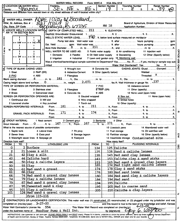
KGS Home Page Water Well Data base Specific Water Well Detail
Water Resources

Well T8S, R39W, Sec. 19, SE NE NE, Action: Constructed

Location Info
Owner: KDHE/City of Goodland Status: Constructed
Location: T8S, R39W, Sec. 19, SE NE NE County: Sherman
Directions:
Latitude: 39.3484863 Longitude: -101.7081735 Datum NAD 27
Latitude: 39.348486 Longitude: -101.7086235 Datum NAD 83
Longitude and latitude calculated by Survey from township-range-section-quarter calls. Only good to within the quarter call accuracy.
View well on interactive map This link will create a new window and display an interactive map of this well and its neighbors.
General Info
Well Depth: 211 ft. Elevation: ft.
Static Water Level: 190 ft. Est. Yield: gpm.
Comp. Date: 27-Mar-2000 Well Use: Monitoring well/observation/piezometer
DWR Applic. #: Other ID: MW 18
Driller Info
Driller: Jay C. Woofter Pump & Well, Inc. License #: 554
Scanned Form
View form(s) on screen Download scan(s)
The download files contain one or more TIFF images compressed into a ZIP archive. Your browser may be already set up to decompress these files. The TIFFs are 300 dpi archival-quality scans of the WWC5 forms and can be viewed by software like Adobe PhotoShop.
Chemical Sample Submitted?:
Water Well disinfected?:
Casing Info
Casing Type:
Casing Joints:
Diam: in. to ft
Casing height above land surface: in
Casing Weight: lbs/ft
Wall thickness or gauge no.:
Screen and Perforation Info
Screen Type: Screen Openings:
Screen-perforated intervals From: ft to ft
Gravel pack intervals From: ft to ft
Grout Info
Grout used: From: to ft
Source of Possible Contamination
Source:
Direction from well: Distance: ft
Lithologic Log
(Log data entered by KGS.)
From: 0 ft. to 2 ft. Surface
From: 2 ft. to 21 ft. Loess and silt
From: 21 ft. to 42 ft. Clay and silt
From: 42 ft. to 44 ft. Caliche, hard
From: 44 ft. to 50 ft. Clay and caliche layers
From: 50 ft. to 55 ft. Clay
From: 55 ft. to 61 ft. Medium sand and gravel
From: 61 ft. to 66 ft. Clay
From: 66 ft. to 74 ft. Medium sand and gravel, clay lenses
From: 74 ft. to 79 ft. Clay and caliche lenses
From: 79 ft. to 87 ft. Medium sand and gravel, clay lenses
From: 87 ft. to 95 ft. Cemented sand and clay
From: 95 ft. to 101 ft. Clay and caliche
From: 101 ft. to 124 ft. Medium sand and gravel, clay lenses from 115-116
From: 124 ft. to 125 ft. Caliche
From: 125 ft. to 128 ft. Sand and caliche lenses
From: 128 ft. to 143 ft. Medium sand, clay lenses
From: 143 ft. to 153 ft. Caliche clay and sand streaks
From: 153 ft. to 165 ft. Medium sand and gravel clay layers
From: 165 ft. to 174 ft. Medium tight sand caliche lenses
From: 174 ft. to 178 ft. Clay and sand streaks
From: 178 ft. to 180 ft. Medium sand, loose
From: 180 ft. to 184 ft. Medium sand, clay and caliche layers
From: 184 ft. to 194 ft. Medium sand
From: 194 ft. to 195 ft. Caliche
From: 195 ft. to 205 ft. Medium to coarse sand
From: 205 ft. to 210 ft. Caliche and clay layers

Kansas Geological Survey
Comments to webadmin@kgs.ku.edu
URL=http://www.kgs.ku.edu/Magellan/WaterWell/index.html
Display Programs Updated July 2, 2014
Data added continuously.