|
|
|
Specific Water Well Detail |
|
|
| Location Info | |||
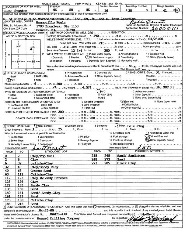
| Owner: Bonneville Fuels | Status: Constructed | ||
| Location: T30S, R41W, Sec. 16, NE SW NE | County: Stanton | ||
| Directions: N of Richfield to Morton, Stanton Co ln, 4 mi N, 3 mi S, E into location | |||
| Latitude: 37.4423725 | Longitude: -101.8039469 | Datum NAD 27 | |
| Latitude: 37.4423918 | Longitude: -101.8043954 | Datum NAD 83 | |
| Longitude and latitude calculated by Survey from township-range-section-quarter calls. Only good to within the quarter call accuracy. | |||
| View well on interactive map | |||
| General Info | ||
| Well Depth: 280 ft. | Elevation: ft. | |
| Static Water Level: 190 ft. | Est. Yield: 100 gpm. | |
| Comp. Date: 25-Apr-2000 | Well Use: Oil Field Water Supply | |
| DWR Applic. #: 20000111 | Other ID: Robb Trust 16-32 | |
| Links | |
| No Wizard information available. | |
| View info from WIMAS Water Right Data base... | |
| Driller Info | ||
| Driller: Howard Drilling Company AG, LLC | License #: 430 | |
| Scanned Form | View scan |
|
Chemical Sample Submitted?:
Water Well disinfected?: | ||
| Casing Info | ||
| Casing Type:
Casing Joints: |
Diam: in. to ft | |
| Casing height above land surface: in
Casing Weight: lbs/ft Wall thickness or gauge no.: | ||
| Screen and Perforation Info | ||
| Screen Type: | Screen Openings: | |
| Screen-perforated intervals | From: ft to ft | |
| Gravel pack intervals | From: ft to ft | |
| Grout Info | ||
| Grout used: | From: to ft | |
| Source of Possible Contamination | ||
| Source: | ||
| Direction from well: | Distance: ft | |
| Lithologic Log
(Log data entered by KGS.) | ||
| From: 0 ft. to 2 ft. | clay/top soil | |
| From: 2 ft. to 6 ft. | clay | |
| From: 6 ft. to 32 ft. | caliche/clay | |
| From: 32 ft. to 40 ft. | clay/sandy clay | |
| From: 40 ft. to 63 ft. | coarse sand | |
| From: 63 ft. to 112 ft. | caliche/clay | |
| From: 112 ft. to 123 ft. | clay with sandy streaks | |
| From: 123 ft. to 129 ft. | clay | |
| From: 129 ft. to 135 ft. | sandy clay | |
| From: 135 ft. to 150 ft. | sand | |
| From: 150 ft. to 161 ft. | sand/sandy clay | |
| From: 161 ft. to 173 ft. | sand | |
| From: 173 ft. to 188 ft. | caliche clay | |
| From: 188 ft. to 218 ft. | sand | |
| From: 218 ft. to 248 ft. | sand/sandstone | |
| From: 248 ft. to 273 ft. | sand | |
| From: 273 ft. to 285 ft. | black clay | |