|
|
|
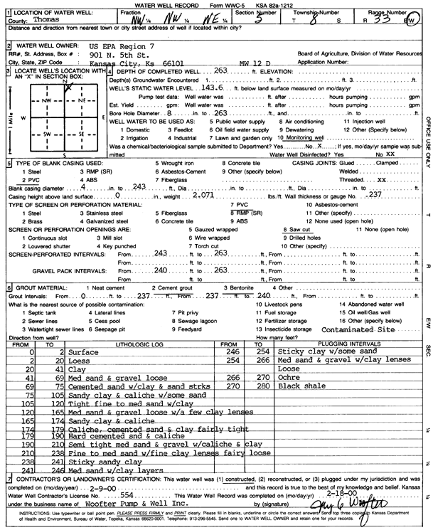
Specific Water Well Detail |
|
|
| Location Info | |||
| Owner: U.S. EPA Region 7 | Status: Constructed | ||
| Location: T8S, R33W, Sec. 5, NW NW NE | County: Thomas | ||
| Directions: | |||
| Latitude: 39.3933826 | Longitude: -101.0254423 | Datum NAD 27 | |
| Latitude: 39.3933864 | Longitude: -101.0258747 | Datum NAD 83 | |
| Longitude and latitude calculated by Survey from township-range-section-quarter calls. Only good to within the quarter call accuracy. | |||
| View well on interactive map | |||
| General Info | ||
| Well Depth: 263 ft. | Elevation: ft. | |
| Static Water Level: 143.6 ft. | Est. Yield: gpm. | |
| Comp. Date: 09-Feb-2000 | Well Use: Monitoring well/observation/piezometer | |
| DWR Applic. #: | Other ID: MW 12 D | |
| Driller Info | ||
| Driller: Jay C. Woofter Pump & Well, Inc. | License #: 554 | |
| Scanned Form | View scan |
|
Chemical Sample Submitted?:
Water Well disinfected?: | ||
| Casing Info | ||
| Casing Type:
Casing Joints: |
Diam: in. to ft | |
| Casing height above land surface: in
Casing Weight: lbs/ft Wall thickness or gauge no.: | ||
| Screen and Perforation Info | ||
| Screen Type: | Screen Openings: | |
| Screen-perforated intervals | From: ft to ft | |
| Gravel pack intervals | From: ft to ft | |
| Grout Info | ||
| Grout used: | From: to ft | |
| Source of Possible Contamination | ||
| Source: | ||
| Direction from well: | Distance: ft | |
| Lithologic Log
(Log data entered by KGS.) | ||
| From: 0 ft. to 2 ft. | Surface | |
| From: 2 ft. to 20 ft. | Loess | |
| From: 20 ft. to 41 ft. | Clay | |
| From: 41 ft. to 69 ft. | Medium sand and gravel loose | |
| From: 69 ft. to 75 ft. | Cemented sand with clay and sand streaks | |
| From: 75 ft. to 105 ft. | Sandy clay and caliche with some sand | |
| From: 105 ft. to 120 ft. | Tight fine to medium sand with clay | |
| From: 120 ft. to 165 ft. | Medium sand and gravel loose with a few clay lenses | |
| From: 165 ft. to 174 ft. | Sandy clay and caliche | |
| From: 174 ft. to 179 ft. | Caliche, cemented sand and clay fairly tight | |
| From: 179 ft. to 190 ft. | Hard cemented sand and caliche | |
| From: 190 ft. to 210 ft. | Semi tight medium sand and gravel with caliche and clay | |
| From: 210 ft. to 238 ft. | Fine to medium sand with fine clay lenses fairly loose | |
| From: 238 ft. to 241 ft. | Sticky sandy clay | |
| From: 241 ft. to 246 ft. | Medium sand with clay layers | |
| From: 246 ft. to 254 ft. | Sticky clay with some sand | |
| From: 254 ft. to 266 ft. | Medium sand and gravel with clay lenses loose | |
| From: 266 ft. to 270 ft. | Ochre | |
| From: 270 ft. to 280 ft. | Black shale | |