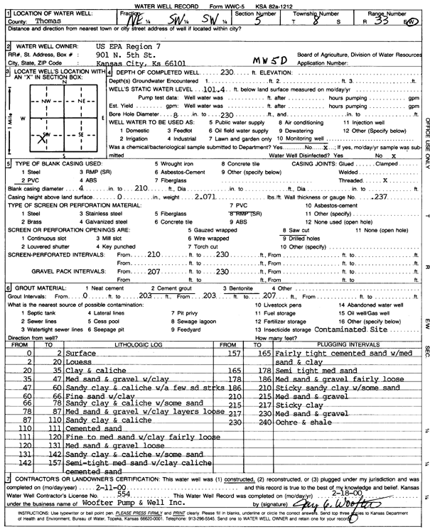
KGS Home Page Water Well Data base Specific Water Well Detail
Water Resources

Well T8S, R33W, Sec. 5, NE SW SW, Action: Constructed

Location Info
Owner: U.S. EPA Region 7 Status: Constructed
Location: T8S, R33W, Sec. 5, NE SW SW County: Thomas
Directions:
Latitude: 39.3825418 Longitude: -101.0325947 Datum NAD 27
Latitude: 39.3825457 Longitude: -101.0330272 Datum NAD 83
Longitude and latitude calculated by Survey from township-range-section-quarter calls. Only good to within the quarter call accuracy.
View well on interactive map
General Info
Well Depth: 230 ft. Elevation: ft.
Static Water Level: 101.4 ft. Est. Yield: gpm.
Comp. Date: 11-Feb-2000 Well Use: Monitoring well/observation/piezometer
DWR Applic. #: Other ID: MW 5 D
Driller Info
Driller: Jay C. Woofter Pump & Well, Inc. License #: 554
Scanned Form
View form(s) on screen Download scan(s)
The download files contain one or more TIFF images compressed into a ZIP archive. Your browser may be already set up to decompress these files. The TIFFs are 300 dpi archival-quality scans of the WWC5 forms and can be viewed by software like Adobe PhotoShop.
Chemical Sample Submitted?:
Water Well disinfected?:
Casing Info
Casing Type:
Casing Joints:
Diam: in. to ft
Casing height above land surface: in
Casing Weight: lbs/ft
Wall thickness or gauge no.:
Screen and Perforation Info
Screen Type: Screen Openings:
Screen-perforated intervals From: ft to ft
Gravel pack intervals From: ft to ft
Grout Info
Grout used: From: to ft
Source of Possible Contamination
Source:
Direction from well: Distance: ft
Lithologic Log
(Log data entered by KGS.)
From: 0 ft. to 2 ft. Surface
From: 2 ft. to 20 ft. Loess
From: 20 ft. to 35 ft. Clay and caliche
From: 35 ft. to 47 ft. Medium sand and gravel with clay
From: 47 ft. to 60 ft. Sand clay and caliche with a few sand streaks
From: 60 ft. to 66 ft. Fine sand with clay
From: 66 ft. to 78 ft. Sandy clay and caliche with some sand
From: 78 ft. to 87 ft. Medium sand and gravel with clay layers loose
From: 87 ft. to 110 ft. Sandy clay and caliche
From: 110 ft. to 111 ft. Cemented sand
From: 111 ft. to 120 ft. Fine to medium sand with clay fairly loose
From: 120 ft. to 131 ft. Medium sand and gravel loose
From: 131 ft. to 142 ft. Sandy clay and caliche with some sand
From: 142 ft. to 157 ft. Semi-tight medium sand with clay caliche cemented sand
From: 157 ft. to 165 ft. Fairly tight cemented sand with medium sand and clay
From: 165 ft. to 178 ft. Semi tight medium sand
From: 178 ft. to 186 ft. Medium sand and gravel fairly loose
From: 186 ft. to 210 ft. Sticky sandy clay with some sand
From: 210 ft. to 215 ft. Medium sand and gravel
From: 215 ft. to 217 ft. Sticky clay
From: 217 ft. to 230 ft. Medium sand and gravel
From: 230 ft. to 240 ft. Ochre and shale

Kansas Geological Survey
Comments to kgs-webadmin@ku.edu
URL=http://www.kgs.ku.edu/Magellan/WaterWell/index.html
Display Programs Updated January 2, 2025
Data added continuously.