|
|
|
Specific Water Well Detail |
|
|
| Location Info | |||
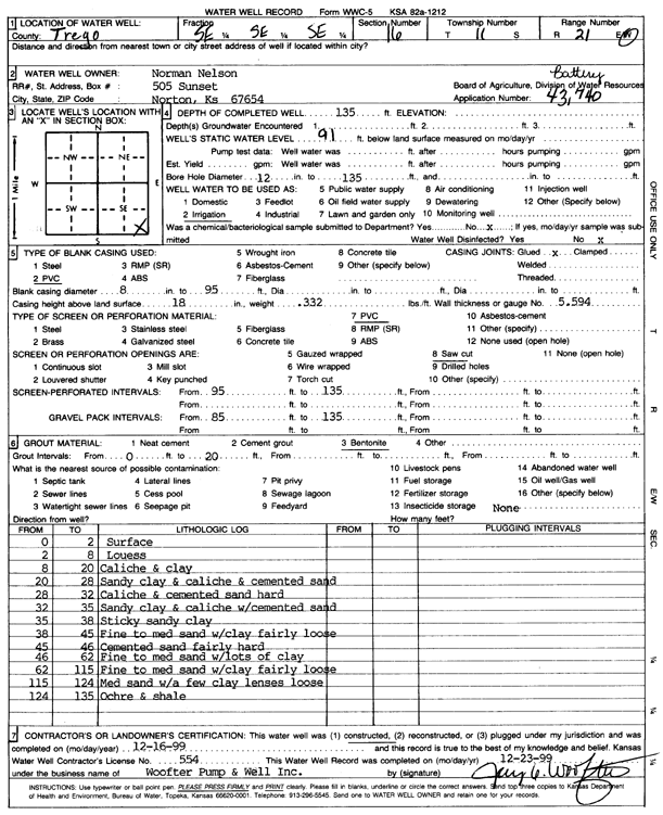
| Owner: Nelson, Norman | Status: Constructed | ||
| Location: T11S, R21W, Sec. 16, SE SE SE | County: Trego | ||
| Directions: | |||
| Latitude: 39.0891127 | Longitude: -99.649207 | Datum NAD 27 | |
| Latitude: 39.0891215 | Longitude: -99.6495987 | Datum NAD 83 | |
| Longitude and latitude calculated by Survey from township-range-section-quarter calls. Only good to within the quarter call accuracy. | |||
| View well on interactive map | |||
| General Info | ||
| Well Depth: 135 ft. | Elevation: ft. | |
| Static Water Level: 91 ft. | Est. Yield: gpm. | |
| Comp. Date: 16-Dec-1999 | Well Use: Irrigation | |
| DWR Applic. #: 43740 | Other ID: | |
| Links | |
| No Wizard information available. | |
| View info from WIMAS Water Right Data base... | |
| Driller Info | ||
| Driller: Jay C. Woofter Pump & Well, Inc. | License #: 554 | |
| Scanned Form | View scan |
|
Chemical Sample Submitted?:
Water Well disinfected?: | ||
| Casing Info | ||
| Casing Type:
Casing Joints: |
Diam: in. to ft | |
| Casing height above land surface: in
Casing Weight: lbs/ft Wall thickness or gauge no.: | ||
| Screen and Perforation Info | ||
| Screen Type: | Screen Openings: | |
| Screen-perforated intervals | From: ft to ft | |
| Gravel pack intervals | From: ft to ft | |
| Grout Info | ||
| Grout used: | From: to ft | |
| Source of Possible Contamination | ||
| Source: | ||
| Direction from well: | Distance: ft | |
| Lithologic Log
(Log data entered by KGS.) | ||
| From: 0 ft. to 2 ft. | Surface | |
| From: 2 ft. to 8 ft. | Loess | |
| From: 8 ft. to 20 ft. | Caliche and clay | |
| From: 20 ft. to 28 ft. | Sandy clay and caliche and cemented sand | |
| From: 28 ft. to 32 ft. | Caliche and cemented sand hard | |
| From: 32 ft. to 35 ft. | Sandy clay and caliche with cemented sand | |
| From: 35 ft. to 38 ft. | Sticky sandy clay | |
| From: 38 ft. to 45 ft. | Fine to medium sand with clay fairly loose | |
| From: 45 ft. to 46 ft. | Cemented sand fairly hard | |
| From: 46 ft. to 62 ft. | Fine to medium sand with lots of clay | |
| From: 62 ft. to 115 ft. | Fine to medium sand with clay fairly loose | |
| From: 115 ft. to 124 ft. | Medium sand with a few clay lenses loose | |
| From: 124 ft. to 135 ft. | Ochre and shale | |