|
|
|
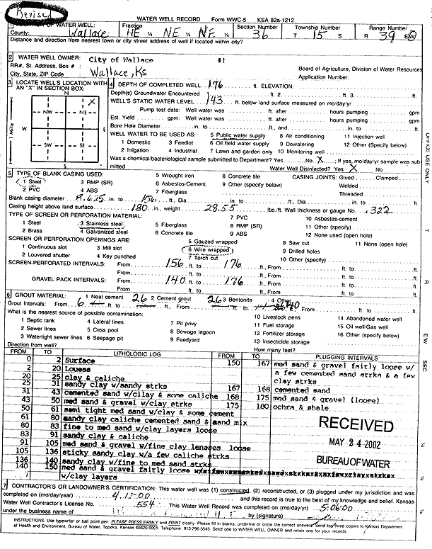
Specific Water Well Detail |
|
|
| Location Info | |||
| Owner: City of Wallace | Status: Constructed | ||
| Location: T15S, R39W, Sec. 36, NE NE NE | County: Wallace | ||
| Directions: | |||
| Latitude: 38.7129742 | Longitude: -101.596084 | Datum NAD 27 | |
| Latitude: 38.7129871 | Longitude: -101.5965294 | Datum NAD 83 | |
| Longitude and latitude calculated by Survey from township-range-section-quarter calls. Only good to within the quarter call accuracy. | |||
| View well on interactive map | |||
| General Info | ||
| Well Depth: 176 ft. | Elevation: ft. | |
| Static Water Level: 143 ft. | Est. Yield: gpm. | |
| Comp. Date: 12-Apr-2000 | Well Use: Public Water Supply | |
| DWR Applic. #: | Other ID: Well 1 | |
| Driller Info | ||
| Driller: Jay C. Woofter Pump & Well, Inc. | License #: 554 | |
| Scanned Form | View scan |
|
Chemical Sample Submitted?:
Water Well disinfected?: | ||
| Casing Info | ||
| Casing Type:
Casing Joints: |
Diam: in. to ft | |
| Casing height above land surface: in
Casing Weight: lbs/ft Wall thickness or gauge no.: | ||
| Screen and Perforation Info | ||
| Screen Type: | Screen Openings: | |
| Screen-perforated intervals | From: ft to ft | |
| Gravel pack intervals | From: ft to ft | |
| Grout Info | ||
| Grout used: | From: to ft | |
| Source of Possible Contamination | ||
| Source: | ||
| Direction from well: | Distance: ft | |
| Lithologic Log
(Log data entered by KGS.) | ||
| From: 0 ft. to 2 ft. | Surface | |
| From: 2 ft. to 20 ft. | Loess | |
| From: 20 ft. to 25 ft. | Clay and caliche | |
| From: 25 ft. to 31 ft. | Sandy clay with sandy streaks | |
| From: 31 ft. to 43 ft. | Cemented sand with clay and some caliche | |
| From: 43 ft. to 50 ft. | Medium sand and gravel with clay streaks | |
| From: 50 ft. to 61 ft. | Semi tight medium sand with clay and some cement | |
| From: 61 ft. to 80 ft. | Sandy clay, caliche, cemented sand and sand mix | |
| From: 80 ft. to 83 ft. | Fine to medium sand with clay layers, loose | |
| From: 83 ft. to 91 ft. | Sandy clay and caliche | |
| From: 91 ft. to 105 ft. | Medium sand and gravel with fine clay lenses, loose | |
| From: 105 ft. to 136 ft. | Sticky sandy clay with a few caliche streaks | |
| From: 136 ft. to 140 ft. | Sandy clay with fine to medium sand streaks | |
| From: 140 ft. to 150 ft. | Medium sand and gravel, fairly loose, with clay layers | |
| From: 150 ft. to 167 ft. | Medium sand and gravel, fairly loose, with a few cemented sand streaks and a few clay streaks | |
| From: 167 ft. to 168 ft. | Cemented sand | |
| From: 168 ft. to 175 ft. | Medium sand and gravel, loose | |
| From: 175 ft. to 180 ft. | Ochre and shale | |