|
|
|
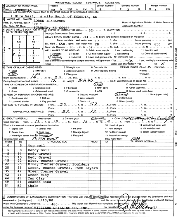
Specific Water Well Detail |
|
|
| Location Info | |||
| Owner: Isasacson, Loren | Status: Constructed | ||
| Location: T3S, R4W, Sec. 8, SW NW SW | County: Republic | ||
| Directions: from Scandia, 1 mi W and 0.5 mi N | |||
| Latitude: 39.8031243 | Longitude: -97.7994646 | Datum NAD 27 | |
| Latitude: 39.8031322 | Longitude: -97.7997857 | Datum NAD 83 | |
| Longitude and latitude calculated by Survey from township-range-section-quarter calls. Only good to within the quarter call accuracy. | |||
| View well on interactive map | |||
| General Info | ||
| Well Depth: 52 ft. | Elevation: ft. | |
| Static Water Level: 11 ft. | Est. Yield: 650 gpm. | |
| Comp. Date: 10-Jun-2000 | Well Use: Irrigation | |
| DWR Applic. #: | Other ID: | |
| Driller Info | ||
| Driller: Ron Williams Drilling Co., Inc. | License #: 480 | |
| Scanned Form | View scan |
|
Chemical Sample Submitted?:
Water Well disinfected?: | ||
| Casing Info | ||
| Casing Type:
Casing Joints: |
Diam: in. to ft | |
| Casing height above land surface: in
Casing Weight: lbs/ft Wall thickness or gauge no.: | ||
| Screen and Perforation Info | ||
| Screen Type: | Screen Openings: | |
| Screen-perforated intervals | From: ft to ft | |
| Gravel pack intervals | From: ft to ft | |
| Grout Info | ||
| Grout used: | From: to ft | |
| Source of Possible Contamination | ||
| Source: | ||
| Direction from well: | Distance: ft | |
| Lithologic Log
(Log data entered by KGS.) | ||
| From: 0 ft. to 5 ft. | Topsoil | |
| From: 5 ft. to 8 ft. | Sandy soil | |
| From: 8 ft. to 11 ft. | Medium gravel | |
| From: 11 ft. to 15 ft. | Medium gravel | |
| From: 15 ft. to 22 ft. | Blue, coarse gravel | |
| From: 22 ft. to 25 ft. | Blue, coarse gravel, boulders | |
| From: 25 ft. to 35 ft. | Green, coarse gravel, rock layers | |
| From: 35 ft. to 42 ft. | Green coarse gravel | |
| From: 42 ft. to 44 ft. | Green clay | |
| From: 44 ft. to 49 ft. | Tan clay | |
| From: 49 ft. to 51 ft. | Coarse sand | |
| From: 51 ft. to 52 ft. | Shale | |