|
|
|
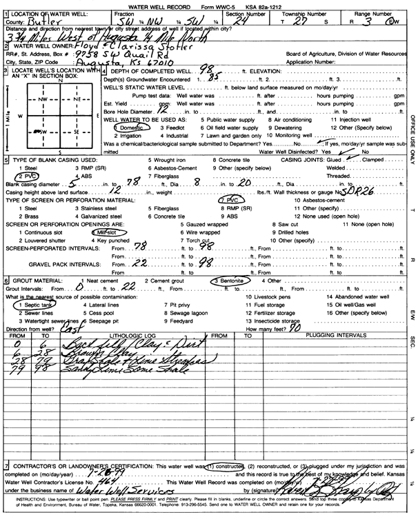
Specific Water Well Detail |
|
|
| Location Info | |||
| Owner: Stotler, Floyd and Clarissa | Status: Constructed | ||
| Location: T27S, R3E, Sec. 24, SW NW SW | County: Butler | ||
| Directions: from Augusta: 3.75 mi W, .25 mi N | |||
| Latitude: 37.6841226 | Longitude: -97.0605393 | Datum NAD 27 | |
| Latitude: 37.6841395 | Longitude: -97.0608554 | Datum NAD 83 | |
| Longitude and latitude calculated by Survey from township-range-section-quarter calls. Only good to within the quarter call accuracy. | |||
| View well on interactive map | |||
| General Info | ||
| Well Depth: 98 ft. | Elevation: ft. | |
| Static Water Level: ft. | Est. Yield: gpm. | |
| Comp. Date: 21-Jul-1999 | Well Use: Domestic | |
| DWR Applic. #: | Other ID: | |
| Driller Info | ||
| Driller: Robert L. Sharp Water Well Services | License #: 464 | |
| Scanned Form | View scan |
|
Chemical Sample Submitted?:
Water Well disinfected?: | ||
| Casing Info | ||
| Casing Type:
Casing Joints: |
Diam: in. to ft | |
| Casing height above land surface: in
Casing Weight: lbs/ft Wall thickness or gauge no.: | ||
| Screen and Perforation Info | ||
| Screen Type: | Screen Openings: | |
| Screen-perforated intervals | From: ft to ft | |
| Gravel pack intervals | From: ft to ft | |
| Grout Info | ||
| Grout used: | From: to ft | |
| Source of Possible Contamination | ||
| Source: | ||
| Direction from well: | Distance: ft | |
| Lithologic Log
(Log data entered by KGS.) | ||
| From: 0 ft. to 6 ft. | Black shell, clay, and dirt | |
| From: 6 ft. to 28 ft. | Brown clay | |
| From: 28 ft. to 79 ft. | Gray shale and lime streaks | |
| From: 79 ft. to 98 ft. | Sandy lime some shale | |