|
|
|
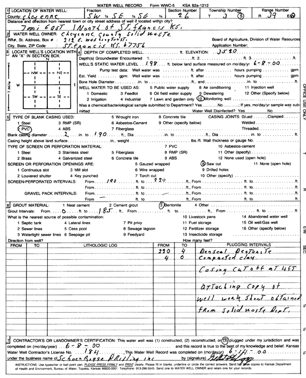
Specific Water Well Detail |
|
|
| Location Info | |||
| Owner: Cheyenne County Solid Waste | Status: Plugged | ||
| Location: T3S, R39W, Sec. 26, SW SE SE | County: Cheyenne | ||
| Directions: from St. Francis, 7 mi E and 1 mi N | |||
| Latitude: 39.7576282 | Longitude: -101.6581728 | Datum NAD 27 | |
| Latitude: 39.7576222 | Longitude: -101.6586206 | Datum NAD 83 | |
| Longitude and latitude calculated by Survey from township-range-section-quarter calls. Only good to within the quarter call accuracy. | |||
| View well on interactive map | |||
| General Info | ||
| Well Depth: 220 ft. | Elevation: 3520 ft. | |
| Static Water Level: 198 ft. | Est. Yield: gpm. | |
| Comp. Date: 08-Jun-2000 | Well Use: Monitoring well/observation/piezometer | |
| DWR Applic. #: | Other ID: | |
| Driller Info | ||
| Driller: Schoenrogge Drilling, Inc. | License #: 184 | |
| Scanned Form | View scan |
| Casing Info | ||
|
Casing Type:
Diam: in. Casing height above land surface: in | ||
| Grout Info | ||
| Grout used: | From: to ft | |
| Source of Possible Contamination | ||
| Source: | ||
| Direction from well: | Distance: ft | |