|
|
|
Specific Water Well Detail |
|
|
| Location Info | |||
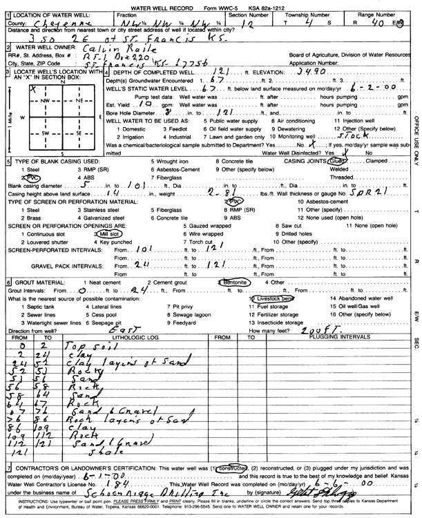
| Owner: Raile, Calvin | Status: Constructed | ||
| Location: T4S, R40W, Sec. 12, NW NW NW | County: Cheyenne | ||
| Directions: from St. Francis, 3 mi S and 2 mi E | |||
| Latitude: 39.7266479 | Longitude: -101.7667421 | Datum NAD 27 | |
| Latitude: 39.7266411 | Longitude: -101.7671935 | Datum NAD 83 | |
| Longitude and latitude calculated by Survey from township-range-section-quarter calls. Only good to within the quarter call accuracy. | |||
| View well on interactive map | |||
| General Info | ||
| Well Depth: 121 ft. | Elevation: 3490 ft. | |
| Static Water Level: 67 ft. | Est. Yield: 10 gpm. | |
| Comp. Date: 01-Jun-2000 | Well Use: Domestic, Livestock | |
| DWR Applic. #: | Other ID: | |
| Driller Info | ||
| Driller: Schoenrogge Drilling, Inc. | License #: 184 | |
| Scanned Form | View scan |
|
Chemical Sample Submitted?:
Water Well disinfected?: | ||
| Casing Info | ||
| Casing Type:
Casing Joints: |
Diam: in. to ft | |
| Casing height above land surface: in
Casing Weight: lbs/ft Wall thickness or gauge no.: | ||
| Screen and Perforation Info | ||
| Screen Type: | Screen Openings: | |
| Screen-perforated intervals | From: ft to ft | |
| Gravel pack intervals | From: ft to ft | |
| Grout Info | ||
| Grout used: | From: to ft | |
| Source of Possible Contamination | ||
| Source: | ||
| Direction from well: | Distance: ft | |
| Lithologic Log
(Log data entered by KGS.) | ||
| From: 0 ft. to 2 ft. | top soil | |
| From: 2 ft. to 24 ft. | clay | |
| From: 24 ft. to 52 ft. | clay with layers of sand | |
| From: 52 ft. to 53 ft. | rock | |
| From: 53 ft. to 56 ft. | sand | |
| From: 56 ft. to 58 ft. | rock | |
| From: 58 ft. to 64 ft. | sand | |
| From: 64 ft. to 67 ft. | rock | |
| From: 67 ft. to 76 ft. | sand and gravel | |
| From: 76 ft. to 86 ft. | rock with layers of sand | |
| From: 86 ft. to 109 ft. | clay | |
| From: 109 ft. to 112 ft. | rock | |
| From: 112 ft. to 121 ft. | sand and gravel | |
| From: 121 ft. to ft. | shale | |