|
|
|
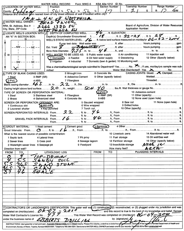
Specific Water Well Detail |
|
|
| Location Info | |||
| Owner: Payer, Brad | Status: Constructed | ||
| Location: T21S, R17E, Sec. 17, SW SW SW | County: Coffey | ||
| Directions: from Westphilia: 1 mi N, 4 mi W | |||
| Latitude: 38.2137644 | Longitude: -95.5713078 | Datum NAD 27 | |
| Latitude: 38.2137867 | Longitude: -95.5715695 | Datum NAD 83 | |
| Longitude and latitude calculated by Survey from township-range-section-quarter calls. Only good to within the quarter call accuracy. | |||
| View well on interactive map | |||
| General Info | ||
| Well Depth: 46 ft. | Elevation: ft. | |
| Static Water Level: 16 ft. | Est. Yield: 8 gpm. | |
| Comp. Date: 02-Jun-2000 | Well Use: Domestic | |
| DWR Applic. #: | Other ID: | |
| Driller Info | ||
| Driller: Grogan Ebberts Drilling | License #: 479 | |
| Scanned Form | View scan |
|
Chemical Sample Submitted?:
Water Well disinfected?: | ||
| Casing Info | ||
| Casing Type:
Casing Joints: |
Diam: in. to ft | |
| Casing height above land surface: in
Casing Weight: lbs/ft Wall thickness or gauge no.: | ||
| Screen and Perforation Info | ||
| Screen Type: | Screen Openings: | |
| Screen-perforated intervals | From: ft to ft | |
| Gravel pack intervals | From: ft to ft | |
| Grout Info | ||
| Grout used: | From: to ft | |
| Source of Possible Contamination | ||
| Source: | ||
| Direction from well: | Distance: ft | |
| Lithologic Log
(Log data entered by KGS.) | ||
| From: 0 ft. to 4 ft. | Top brown | |
| From: 4 ft. to 5.5 ft. | Sandy soil | |
| From: 5.5 ft. to 36.5 ft. | Sandstone | |
| From: 36.5 ft. to 37 ft. | Clay | |
| From: 37 ft. to 46 ft. | Shale | |