|
|
|
Specific Water Well Detail |
|
|
| Location Info | |||
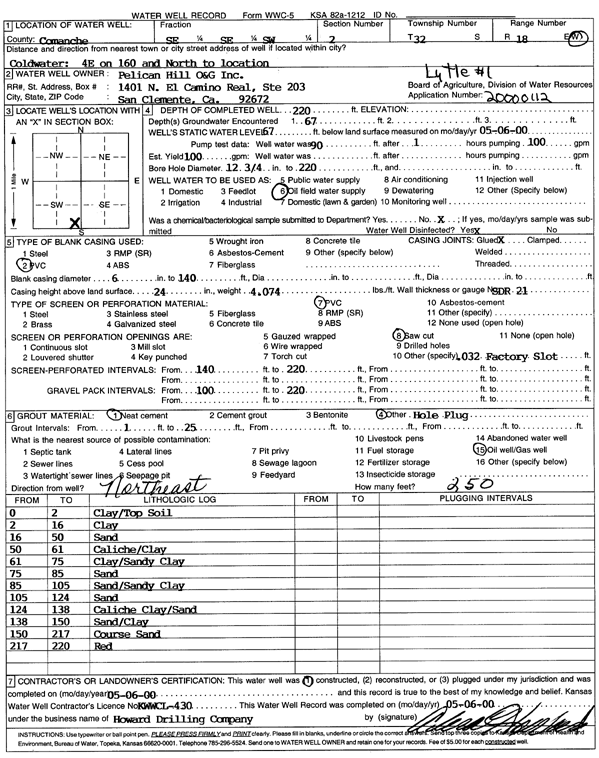
| Owner: Pelican Hill O&G Inc. | Status: Constructed | ||
| Location: T32S, R18W, Sec. 2, SE SE SW | County: Comanche | ||
| Directions: from Coldwater: 4 mi E on 160, N to location | |||
| Latitude: 37.2819752 | Longitude: -99.2473336 | Datum NAD 27 | |
| Latitude: 37.281999 | Longitude: -99.2477232 | Datum NAD 83 | |
| Longitude and latitude calculated by Survey from township-range-section-quarter calls. Only good to within the quarter call accuracy. | |||
| View well on interactive map | |||
| General Info | ||
| Well Depth: 220 ft. | Elevation: ft. | |
| Static Water Level: 67 ft. | Est. Yield: 100 gpm. | |
| Comp. Date: 06-May-2000 | Well Use: Oil Field Water Supply | |
| DWR Applic. #: 20000112 | Other ID: Lytle 1 | |
| Links | |
| No Wizard information available. | |
| View info from WIMAS Water Right Data base... | |
| Driller Info | ||
| Driller: Howard Drilling Company AG, LLC | License #: 430 | |
| Scanned Form | View scan |
|
Chemical Sample Submitted?:
Water Well disinfected?: | ||
| Casing Info | ||
| Casing Type:
Casing Joints: |
Diam: in. to ft | |
| Casing height above land surface: in
Casing Weight: lbs/ft Wall thickness or gauge no.: | ||
| Screen and Perforation Info | ||
| Screen Type: | Screen Openings: | |
| Screen-perforated intervals | From: ft to ft | |
| Gravel pack intervals | From: ft to ft | |
| Grout Info | ||
| Grout used: | From: to ft | |
| Source of Possible Contamination | ||
| Source: | ||
| Direction from well: | Distance: ft | |
| Lithologic Log
(Log data entered by KGS.) | ||
| From: 0 ft. to 2 ft. | Clay, topsoil | |
| From: 2 ft. to 16 ft. | Clay | |
| From: 16 ft. to 50 ft. | Sand | |
| From: 50 ft. to 61 ft. | Caliche, clay | |
| From: 61 ft. to 75 ft. | Clay, sandy clay | |
| From: 75 ft. to 85 ft. | Sand | |
| From: 85 ft. to 105 ft. | Sand, sandy clay | |
| From: 105 ft. to 124 ft. | Sand | |
| From: 124 ft. to 138 ft. | Caliche clay, sand | |
| From: 138 ft. to 150 ft. | Sand, clay | |
| From: 150 ft. to 217 ft. | Coarse sand | |
| From: 217 ft. to 220 ft. | Red | |