|
|
|
Specific Water Well Detail |
|
|
| Location Info | |||
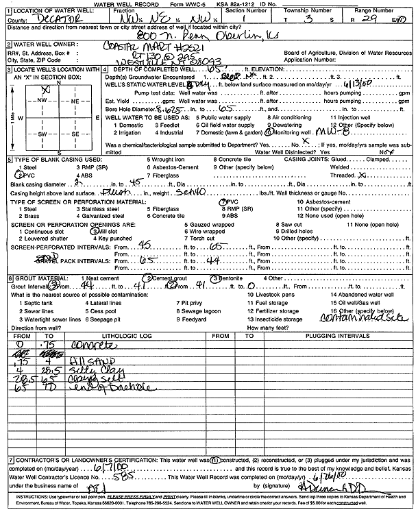
| Owner: Coastal Mart #2521 | Status: Constructed | ||
| Location: T3S, R29W, Sec. 1, NW NE NW | County: Decatur | ||
| Directions: 800 N Penn, Oberlin | |||
| Latitude: 39.8270945 | Longitude: -100.5279671 | Datum NAD 27 | |
| Latitude: 39.8270997 | Longitude: -100.5283905 | Datum NAD 83 | |
| Longitude and latitude calculated by Survey from township-range-section-quarter calls. Only good to within the quarter call accuracy. | |||
| View well on interactive map | |||
| General Info | ||
| Well Depth: 65 ft. | Elevation: ft. | |
| Static Water Level: ft. | Est. Yield: gpm. | |
| Comp. Date: 07-Jun-2000 | Well Use: Monitoring well/observation/piezometer | |
| DWR Applic. #: | Other ID: MW 8 | |
| Driller Info | ||
| Driller: Associated Environmental, Inc. | License #: 585 | |
| Scanned Form | View scan |
|
Chemical Sample Submitted?:
Water Well disinfected?: | ||
| Casing Info | ||
| Casing Type:
Casing Joints: |
Diam: in. to ft | |
| Casing height above land surface: in
Casing Weight: lbs/ft Wall thickness or gauge no.: | ||
| Screen and Perforation Info | ||
| Screen Type: | Screen Openings: | |
| Screen-perforated intervals | From: ft to ft | |
| Gravel pack intervals | From: ft to ft | |
| Grout Info | ||
| Grout used: | From: to ft | |
| Source of Possible Contamination | ||
| Source: | ||
| Direction from well: | Distance: ft | |
| Lithologic Log
(Log data entered by KGS.) | ||
| From: 0 ft. to .8 ft. | Concrete | |
| From: .8 ft. to 4 ft. | Fill sand | |
| From: 4 ft. to 28.5 ft. | Silty clay | |
| From: 28.5 ft. to 65 ft. | Clayey silt | |