|
|
|
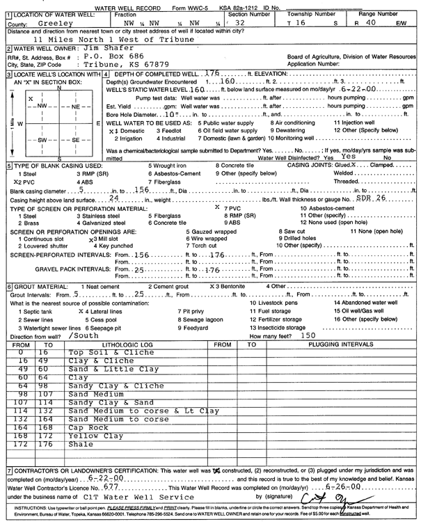
Specific Water Well Detail |
|
|
| Location Info | |||
| Owner: Shafer, Jim | Status: Constructed | ||
| Location: T16S, R40W, Sec. 32, NW NW NW | County: Greeley | ||
| Directions: from Tribune, 11 mi N and 1 mi W | |||
| Latitude: 38.6247063 | Longitude: -101.7695505 | Datum NAD 27 | |
| Latitude: 38.6247201 | Longitude: -101.7700005 | Datum NAD 83 | |
| Longitude and latitude calculated by Survey from township-range-section-quarter calls. Only good to within the quarter call accuracy. | |||
| View well on interactive map | |||
| General Info | ||
| Well Depth: 176 ft. | Elevation: ft. | |
| Static Water Level: 160 ft. | Est. Yield: gpm. | |
| Comp. Date: 22-Jun-2000 | Well Use: Domestic | |
| DWR Applic. #: | Other ID: | |
| Driller Info | ||
| Driller: CLT Inc. | License #: 677 | |
| Scanned Form | View scan |
|
Chemical Sample Submitted?:
Water Well disinfected?: | ||
| Casing Info | ||
| Casing Type:
Casing Joints: |
Diam: in. to ft | |
| Casing height above land surface: in
Casing Weight: lbs/ft Wall thickness or gauge no.: | ||
| Screen and Perforation Info | ||
| Screen Type: | Screen Openings: | |
| Screen-perforated intervals | From: ft to ft | |
| Gravel pack intervals | From: ft to ft | |
| Grout Info | ||
| Grout used: | From: to ft | |
| Source of Possible Contamination | ||
| Source: | ||
| Direction from well: | Distance: ft | |
| Lithologic Log
(Log data entered by KGS.) | ||
| From: 0 ft. to 16 ft. | Top soil and caliche | |
| From: 16 ft. to 49 ft. | Clay and caliche | |
| From: 49 ft. to 60 ft. | Sand and little clay | |
| From: 60 ft. to 64 ft. | Clay | |
| From: 64 ft. to 98 ft. | Sandy clay and caliche | |
| From: 98 ft. to 107 ft. | Sand, medium | |
| From: 107 ft. to 114 ft. | Sandy clay and sand | |
| From: 114 ft. to 132 ft. | Sand, medium to coarse, and light clay | |
| From: 132 ft. to 164 ft. | Sand, medium to coarse | |
| From: 164 ft. to 168 ft. | Cap rock | |
| From: 168 ft. to 172 ft. | Yellow clay | |
| From: 172 ft. to 176 ft. | Shale | |