|
|
|
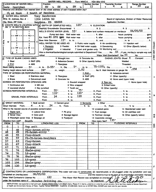
Specific Water Well Detail |
|
|
| Location Info | |||
| Owner: Sanderson, Tony | Status: Constructed | ||
| Location: T4S, R20E, Sec. 12, SW SW SW | County: Doniphan | ||
| Directions: 2.5 mi E, 2 mi S of Bendena | |||
| Latitude: 39.7116018 | Longitude: -95.1327657 | Datum NAD 27 | |
| Latitude: 39.7115983 | Longitude: -95.1330154 | Datum NAD 83 | |
| Longitude and latitude calculated by Survey from township-range-section-quarter calls. Only good to within the quarter call accuracy. | |||
| View well on interactive map | |||
| General Info | ||
| Well Depth: 120 ft. | Elevation: ft. | |
| Static Water Level: 53 ft. | Est. Yield: 1 gpm. | |
| Comp. Date: 05-Jun-2000 | Well Use: Domestic | |
| DWR Applic. #: | Other ID: | |
| Driller Info | ||
| Driller: Strader Drilling Co., Inc. | License #: 182 | |
| Scanned Form | View scan |
|
Chemical Sample Submitted?:
Water Well disinfected?: | ||
| Casing Info | ||
| Casing Type:
Casing Joints: |
Diam: in. to ft | |
| Casing height above land surface: in
Casing Weight: lbs/ft Wall thickness or gauge no.: | ||
| Screen and Perforation Info | ||
| Screen Type: | Screen Openings: | |
| Screen-perforated intervals | From: ft to ft | |
| Gravel pack intervals | From: ft to ft | |
| Grout Info | ||
| Grout used: | From: to ft | |
| Source of Possible Contamination | ||
| Source: | ||
| Direction from well: | Distance: ft | |
| Lithologic Log
(Log data entered by KGS.) | ||
| From: 0 ft. to 1 ft. | Top soil | |
| From: 1 ft. to 48 ft. | Silty clay, brown | |
| From: 48 ft. to 49 ft. | Fine sand, silty, brown | |
| From: 49 ft. to 55 ft. | Clay, black | |
| From: 55 ft. to 57 ft. | Fine sand, coarse sand, brown, boulders | |
| From: 57 ft. to 63 ft. | Clay, brown | |
| From: 63 ft. to 67 ft. | Clay, black | |
| From: 67 ft. to 71 ft. | Limestone, gray | |
| From: 71 ft. to 74 ft. | Shale, gray | |
| From: 74 ft. to 75 ft. | Limestone, gray | |
| From: 75 ft. to 76 ft. | Shale, gray | |
| From: 76 ft. to 103 ft. | Limestone, gray | |
| From: 103 ft. to 104 ft. | Shale, gray | |
| From: 104 ft. to 120 ft. | Limestone, gray | |