|
|
|
Specific Water Well Detail |
|
|
| Location Info | |||
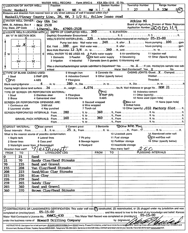
| Owner: Oxy USA, Inc. | Status: Constructed | ||
| Location: T27S, R33W, Sec. 8, SE NE NW | County: Haskell | ||
| Directions: from Haskell/Finney County Line: 2 mi N, 4 mi W, 3.5 mi S, follow lease road | |||
| Latitude: 37.7192871 | Longitude: -100.9536594 | Datum NAD 27 | |
| Latitude: 37.719311 | Longitude: -100.9541044 | Datum NAD 83 | |
| Longitude and latitude calculated by Survey from township-range-section-quarter calls. Only good to within the quarter call accuracy. | |||
| View well on interactive map | |||
| General Info | ||
| Well Depth: 360 ft. | Elevation: ft. | |
| Static Water Level: 220 ft. | Est. Yield: gpm. | |
| Comp. Date: 15-May-2000 | Well Use: Oil Field Water Supply | |
| DWR Applic. #: 2000044 | Other ID: Atkins M 1 | |
| Links | |
| No Wizard information available. | |
| View info from WIMAS Water Right Data base... | |
| Driller Info | ||
| Driller: Howard Drilling Company AG, LLC | License #: 430 | |
| Scanned Form | View scan |
|
Chemical Sample Submitted?:
Water Well disinfected?: | ||
| Casing Info | ||
| Casing Type:
Casing Joints: |
Diam: in. to ft | |
| Casing height above land surface: in
Casing Weight: lbs/ft Wall thickness or gauge no.: | ||
| Screen and Perforation Info | ||
| Screen Type: | Screen Openings: | |
| Screen-perforated intervals | From: ft to ft | |
| Gravel pack intervals | From: ft to ft | |
| Grout Info | ||
| Grout used: | From: to ft | |
| Source of Possible Contamination | ||
| Source: | ||
| Direction from well: | Distance: ft | |
| Lithologic Log
(Log data entered by KGS.) | ||
| From: 0 ft. to 2 ft. | top soil | |
| From: 2 ft. to 25 ft. | fine sand with some brown sandy clay | |
| From: 25 ft. to 46 ft. | brown sandy clay | |
| From: 46 ft. to 77 ft. | brown and yellow sandy clay | |
| From: 77 ft. to 143 ft. | sand fine to med coarse with small gravel some large | |
| From: 143 ft. to 148 ft. | brown sandy clay | |
| From: 148 ft. to 183 ft. | sand fine to med coarse with small gravel | |
| From: 183 ft. to 200 ft. | gray clay | |
| From: 200 ft. to 250 ft. | sand fine to med coarse | |
| From: 250 ft. to 253 ft. | brown sandy clay | |
| From: 253 ft. to 268 ft. | gray clay sticky | |
| From: 268 ft. to 300 ft. | sand fine to med coarse small to med gravel | |
| From: 300 ft. to 301 ft. | sand fine to med coarse some small gravel | |
| From: 301 ft. to 310 ft. | sand fine to med coarse some small gravel | |
| From: 310 ft. to 327 ft. | brown sandy clay | |
| From: 327 ft. to 343 ft. | sand fine to med coarse | |
| From: 343 ft. to 380 ft. | gray clay with some small lime rock ledges | |