|
|
|
Specific Water Well Detail |
|
|
| Location Info | |||
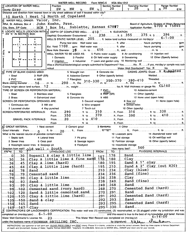
| Owner: Valor Inc. | Status: Constructed | ||
| Location: T28S, R30W, Sec. 30, SW NW SW | County: Gray | ||
| Directions: from Copeland: 1.5 mi N, 1 mi W, 1.25 mi N | |||
| Latitude: 37.5811775 | Longitude: -100.6508356 | Datum NAD 27 | |
| Latitude: 37.5812015 | Longitude: -100.6512696 | Datum NAD 83 | |
| Longitude and latitude calculated by Survey from township-range-section-quarter calls. Only good to within the quarter call accuracy. | |||
| View well on interactive map | |||
| General Info | ||
| Well Depth: 410 ft. | Elevation: ft. | |
| Static Water Level: 205 ft. | Est. Yield: 1100 gpm. | |
| Comp. Date: 01-Jun-2000 | Well Use: Irrigation | |
| DWR Applic. #: 6700 and 15845 | Other ID: | |
| Links | |
| No Wizard information available. | |
| View info from WIMAS Water Right Data base... | |
| Driller Info | ||
| Driller: Donald R. Dunham Drilling, Inc. | License #: 223 | |
| Scanned Form | View scan |
|
Chemical Sample Submitted?:
Water Well disinfected?: | ||
| Casing Info | ||
| Casing Type:
Casing Joints: |
Diam: in. to ft | |
| Casing height above land surface: in
Casing Weight: lbs/ft Wall thickness or gauge no.: | ||
| Screen and Perforation Info | ||
| Screen Type: | Screen Openings: | |
| Screen-perforated intervals | From: ft to ft | |
| Gravel pack intervals | From: ft to ft | |
| Grout Info | ||
| Grout used: | From: to ft | |
| Source of Possible Contamination | ||
| Source: | ||
| Direction from well: | Distance: ft | |
| Lithologic Log
(Log data entered by KGS.) | ||
| From: 0 ft. to 30 ft. | Topsoil and clay and little lime | |
| From: 30 ft. to 36 ft. | Clay and little lime and fine sand | |
| From: 36 ft. to 45 ft. | Clay and lime (hard) | |
| From: 45 ft. to 64 ft. | Clay and little lime (hard) | |
| From: 64 ft. to 78 ft. | Sand | |
| From: 78 ft. to 79 ft. | Cemented sand | |
| From: 79 ft. to 90 ft. | Clay and little lime | |
| From: 90 ft. to 93 ft. | Sand | |
| From: 93 ft. to 99 ft. | Clay and little lime | |
| From: 99 ft. to 102 ft. | Cemented sand (very hard) | |
| From: 102 ft. to 120 ft. | Sand and little cemented sand | |
| From: 120 ft. to 135 ft. | Clay and little lime (hard) | |
| From: 135 ft. to 150 ft. | Sand and clay | |
| From: 150 ft. to 165 ft. | Sand | |
| From: 165 ft. to 167 ft. | Clay | |
| From: 167 ft. to 178 ft. | Sand | |
| From: 178 ft. to 180 ft. | Clay | |
| From: 180 ft. to 195 ft. | Sand and 1 foot clay | |
| From: 195 ft. to 210 ft. | Sand and 2 feet Clay (out H20) | |
| From: 210 ft. to 234 ft. | Clay (blue) | |
| From: 234 ft. to 236 ft. | Sand (fine) | |
| From: 236 ft. to 238 ft. | Clay | |
| From: 238 ft. to 240 ft. | Sand (fine) | |
| From: 240 ft. to 268 ft. | Sand | |
| From: 268 ft. to 270 ft. | Cemented Sand (hard) | |
| From: 270 ft. to 291 ft. | Sand | |
| From: 291 ft. to 292 ft. | Cemented Sand (hard) | |
| From: 292 ft. to 293 ft. | Sand | |
| From: 293 ft. to 295 ft. | Cemented Sand (hard) | |
| From: 295 ft. to 330 ft. | Sand | |