|
|
|
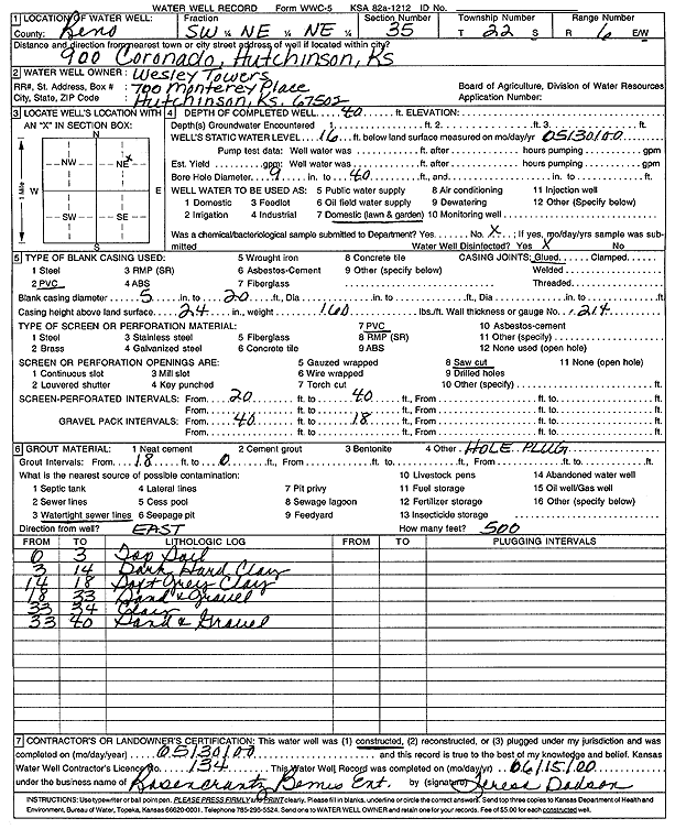
Specific Water Well Detail |
|
|
| Location Info | |||
| Owner: Wesley Towers | Status: Constructed | ||
| Location: T22S, R6W, Sec. 35, SW SW NE NE | County: Reno | ||
| Directions: 900 Coronado, Hutchinson | |||
| Latitude: 38.0970664 | Longitude: -97.9446777 | Datum NAD 27 | |
| Latitude: 38.097078 | Longitude: -97.945009 | Datum NAD 83 | |
| Longitude and latitude from GPS measurements. | |||
| GPS Latitude: 38.097078 | GPS Longitude: -97.945009 | Datum WGS84 | |
| View well on interactive map | |||
| General Info | ||
| Well Depth: 40 ft. | Elevation: ft. | |
| Static Water Level: 16 ft. | Est. Yield: gpm. | |
| Comp. Date: 30-May-2000 | Well Use: Domestic, Lawn and Garden | |
| DWR Applic. #: | Other ID: | |
| Driller Info | ||
| Driller: Rosencrantz-Bemis Enterprises, Inc. | License #: 134 | |
| Scanned Form | View scan |
|
Chemical Sample Submitted?:
Water Well disinfected?: | ||
| Casing Info | ||
| Casing Type:
Casing Joints: |
Diam: in. to ft | |
| Casing height above land surface: in
Casing Weight: lbs/ft Wall thickness or gauge no.: | ||
| Screen and Perforation Info | ||
| Screen Type: | Screen Openings: | |
| Screen-perforated intervals | From: ft to ft | |
| Gravel pack intervals | From: ft to ft | |
| Grout Info | ||
| Grout used: | From: to ft | |
| Source of Possible Contamination | ||
| Source: | ||
| Direction from well: | Distance: ft | |
| Lithologic Log
(Log data entered by KGS.) | ||
| From: 0 ft. to 3 ft. | top soil | |
| From: 3 ft. to 14 ft. | dark hard clay | |
| From: 14 ft. to 18 ft. | soft gray clay | |
| From: 18 ft. to 33 ft. | sand and gravel | |
| From: 33 ft. to 34 ft. | clay | |
| From: 34 ft. to 40 ft. | sand and gravel | |