|
|
|
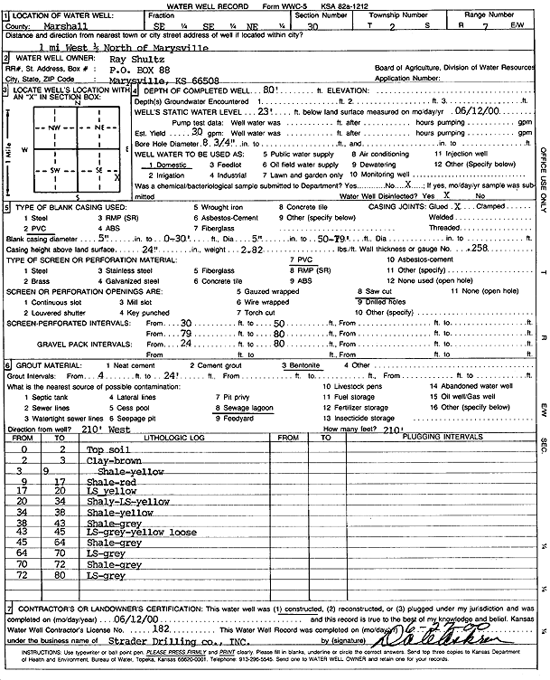
Specific Water Well Detail |
|
|
| Location Info | |||
| Owner: Shultz, Ray | Status: Constructed | ||
| Location: T2S, R7E, Sec. 30, SE SE NE | County: Marshall | ||
| Directions: 1 mi W, .5 mi N of Marysville | |||
| Latitude: 39.8502417 | Longitude: -96.676931 | Datum NAD 27 | |
| Latitude: 39.8502437 | Longitude: -96.6772296 | Datum NAD 83 | |
| Longitude and latitude calculated by Survey from township-range-section-quarter calls. Only good to within the quarter call accuracy. | |||
| View well on interactive map | |||
| General Info | ||
| Well Depth: 80 ft. | Elevation: ft. | |
| Static Water Level: 23 ft. | Est. Yield: 30 gpm. | |
| Comp. Date: 12-Jun-2000 | Well Use: Domestic | |
| DWR Applic. #: | Other ID: | |
| Driller Info | ||
| Driller: Strader Drilling Co., Inc. | License #: 182 | |
| Scanned Form | View scan |
|
Chemical Sample Submitted?:
Water Well disinfected?: | ||
| Casing Info | ||
| Casing Type:
Casing Joints: |
Diam: in. to ft | |
| Casing height above land surface: in
Casing Weight: lbs/ft Wall thickness or gauge no.: | ||
| Screen and Perforation Info | ||
| Screen Type: | Screen Openings: | |
| Screen-perforated intervals | From: ft to ft | |
| Gravel pack intervals | From: ft to ft | |
| Grout Info | ||
| Grout used: | From: to ft | |
| Source of Possible Contamination | ||
| Source: | ||
| Direction from well: | Distance: ft | |
| Lithologic Log
(Log data entered by KGS.) | ||
| From: 0 ft. to 2 ft. | top soil | |
| From: 2 ft. to 3 ft. | clay, brown | |
| From: 3 ft. to 9 ft. | shale, yellow | |
| From: 9 ft. to 17 ft. | shale, red | |
| From: 17 ft. to 20 ft. | limestone, yellow | |
| From: 20 ft. to 34 ft. | shaley limestone, yellow | |
| From: 34 ft. to 38 ft. | shale, yellow | |
| From: 38 ft. to 43 ft. | shale, gray | |
| From: 43 ft. to 45 ft. | limestone, gray-yellow, loose | |
| From: 45 ft. to 64 ft. | shale, gray | |
| From: 64 ft. to 70 ft. | limestone, gray | |
| From: 70 ft. to 72 ft. | shale, gray | |
| From: 72 ft. to 80 ft. | limestone, gray | |