|
|
|
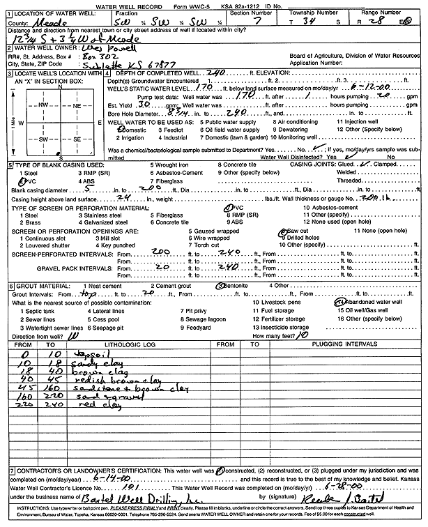
Specific Water Well Detail |
|
|
| Location Info | |||
| Owner: Powell, Wes | Status: Constructed | ||
| Location: T34S, R28W, Sec. 7, SW SW SW | County: Meade | ||
| Directions: from Meade: 12.75 mi S, 3.25 mi W | |||
| Latitude: 37.0979811 | Longitude: -100.41478 | Datum NAD 27 | |
| Latitude: 37.0980066 | Longitude: -100.4152058 | Datum NAD 83 | |
| Longitude and latitude calculated by Survey from township-range-section-quarter calls. Only good to within the quarter call accuracy. | |||
| View well on interactive map | |||
| General Info | ||
| Well Depth: 240 ft. | Elevation: ft. | |
| Static Water Level: 170 ft. | Est. Yield: 30 gpm. | |
| Comp. Date: 14-Jun-2000 | Well Use: Domestic | |
| DWR Applic. #: | Other ID: | |
| Driller Info | ||
| Driller: Reuben Bartel Well Drilling, Inc. | License #: 101 | |
| Scanned Form | View scan |
|
Chemical Sample Submitted?:
Water Well disinfected?: | ||
| Casing Info | ||
| Casing Type:
Casing Joints: |
Diam: in. to ft | |
| Casing height above land surface: in
Casing Weight: lbs/ft Wall thickness or gauge no.: | ||
| Screen and Perforation Info | ||
| Screen Type: | Screen Openings: | |
| Screen-perforated intervals | From: ft to ft | |
| Gravel pack intervals | From: ft to ft | |
| Grout Info | ||
| Grout used: | From: to ft | |
| Source of Possible Contamination | ||
| Source: | ||
| Direction from well: | Distance: ft | |
| Lithologic Log
(Log data entered by KGS.) | ||
| From: 0 ft. to 10 ft. | top soil | |
| From: 10 ft. to 18 ft. | sandy clay | |
| From: 18 ft. to 40 ft. | brown clay | |
| From: 40 ft. to 45 ft. | reddish brown clay | |
| From: 45 ft. to 160 ft. | sandstone and brown clay | |
| From: 160 ft. to 220 ft. | sand and gravel | |
| From: 220 ft. to 240 ft. | red clay | |