|
|
|
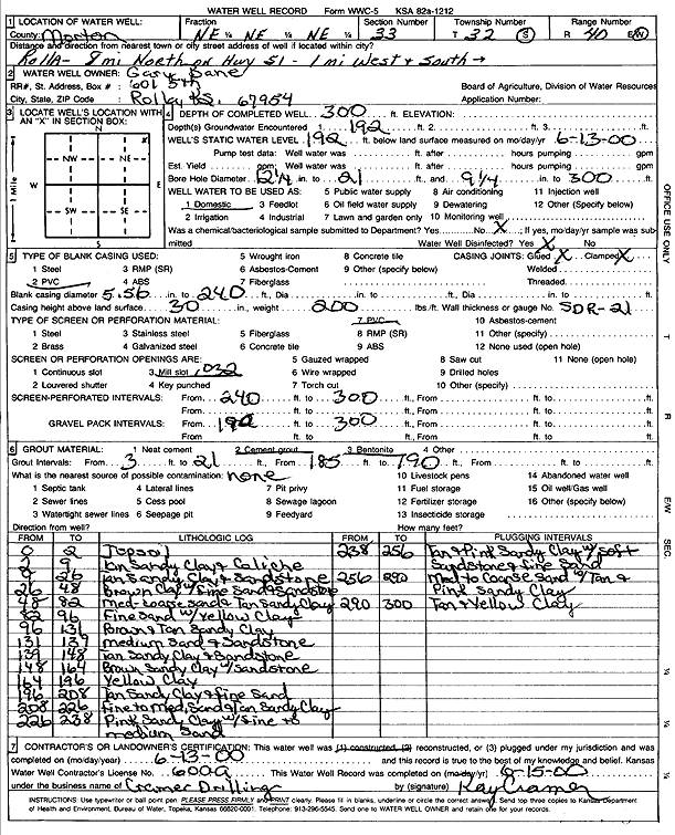
Specific Water Well Detail |
|
|
| Location Info | |||
| Owner: Bane, Gary | Status: Constructed | ||
| Location: T32S, R40W, Sec. 33, NE NE NE | County: Morton | ||
| Directions: from Rolla: 8 mi N on Hwy 51, 1 mi W, 1 mi S | |||
| Latitude: 37.2280709 | Longitude: -101.6655722 | Datum NAD 27 | |
| Latitude: 37.2280949 | Longitude: -101.6660125 | Datum NAD 83 | |
| Longitude and latitude calculated by Survey from township-range-section-quarter calls. Only good to within the quarter call accuracy. | |||
| View well on interactive map | |||
| General Info | ||
| Well Depth: 300 ft. | Elevation: ft. | |
| Static Water Level: 192 ft. | Est. Yield: gpm. | |
| Comp. Date: 13-Jun-2000 | Well Use: Domestic | |
| DWR Applic. #: | Other ID: | |
| Driller Info | ||
| Driller: Ray Cramer Drilling Co. | License #: 600 | |
| Scanned Form | View scan |
|
Chemical Sample Submitted?:
Water Well disinfected?: | ||
| Casing Info | ||
| Casing Type:
Casing Joints: |
Diam: in. to ft | |
| Casing height above land surface: in
Casing Weight: lbs/ft Wall thickness or gauge no.: | ||
| Screen and Perforation Info | ||
| Screen Type: | Screen Openings: | |
| Screen-perforated intervals | From: ft to ft | |
| Gravel pack intervals | From: ft to ft | |
| Grout Info | ||
| Grout used: | From: to ft | |
| Source of Possible Contamination | ||
| Source: | ||
| Direction from well: | Distance: ft | |
| Lithologic Log
(Log data entered by KGS.) | ||
| From: 0 ft. to 2 ft. | topsoil | |
| From: 2 ft. to 9 ft. | tan sandy clay and caliche | |
| From: 9 ft. to 26 ft. | tan sandy clay and sandstone | |
| From: 26 ft. to 48 ft. | brown clay w/fine sand and sandstone | |
| From: 48 ft. to 82 ft. | med-coarse sand and tan sandy clay | |
| From: 82 ft. to 96 ft. | fine sand w/yellow clay | |
| From: 96 ft. to 131 ft. | brown and tan sandy clay | |
| From: 131 ft. to 139 ft. | medium sand and sandstone | |
| From: 139 ft. to 148 ft. | tan sandy clay and sandstone | |
| From: 148 ft. to 164 ft. | brown sandy clay with sandstone | |
| From: 164 ft. to 196 ft. | yellow clay | |
| From: 196 ft. to 208 ft. | tan sandy clay and fine sand | |
| From: 208 ft. to 226 ft. | fine to med. Sand and tan sandy clay | |
| From: 226 ft. to 238 ft. | pink sandy clay w/fine to medium sand | |
| From: 238 ft. to 256 ft. | tan and pink sandy clay with soft sandstone and fine sand | |
| From: 256 ft. to 290 ft. | med to coarse sand with tan and pink sandy clay | |
| From: 290 ft. to 300 ft. | tan and yellow clay | |