|
|
|
Specific Water Well Detail |
|
|
| Location Info | |||
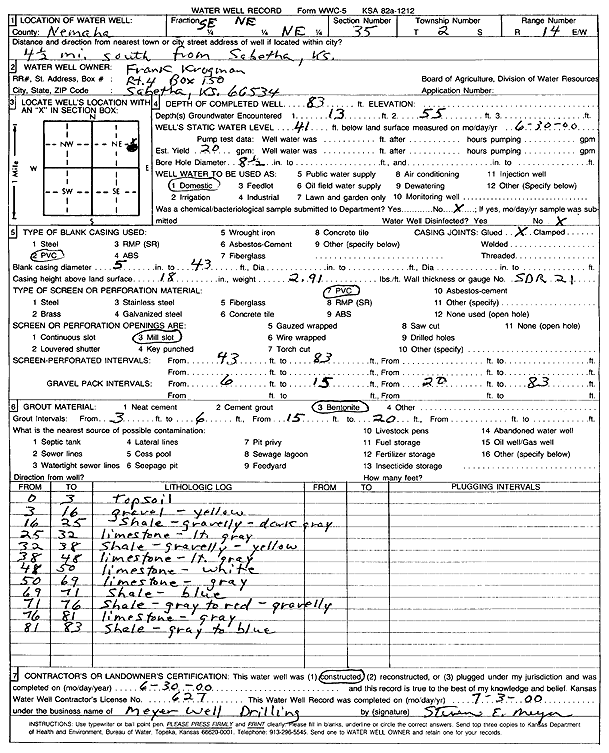
| Owner: Krogman, Frank | Status: Constructed | ||
| Location: T2S, R14E, Sec. 35, SE NE NE | County: Nemaha | ||
| Directions: from Sabetha: 4.5 mi S | |||
| Latitude: 39.8387861 | Longitude: -95.8084068 | Datum NAD 27 | |
| Latitude: 39.8387855 | Longitude: -95.8086736 | Datum NAD 83 | |
| Longitude and latitude calculated by Survey from township-range-section-quarter calls. Only good to within the quarter call accuracy. | |||
| View well on interactive map | |||
| General Info | ||
| Well Depth: 83 ft. | Elevation: ft. | |
| Static Water Level: 41 ft. | Est. Yield: 20 gpm. | |
| Comp. Date: 30-Jun-2000 | Well Use: Domestic | |
| DWR Applic. #: | Other ID: | |
| Driller Info | ||
| Driller: Meyer Well Drilling | License #: 627 | |
| Scanned Form | View scan |
|
Chemical Sample Submitted?:
Water Well disinfected?: | ||
| Casing Info | ||
| Casing Type:
Casing Joints: |
Diam: in. to ft | |
| Casing height above land surface: in
Casing Weight: lbs/ft Wall thickness or gauge no.: | ||
| Screen and Perforation Info | ||
| Screen Type: | Screen Openings: | |
| Screen-perforated intervals | From: ft to ft | |
| Gravel pack intervals | From: ft to ft | |
| Grout Info | ||
| Grout used: | From: to ft | |
| Source of Possible Contamination | ||
| Source: | ||
| Direction from well: | Distance: ft | |
| Lithologic Log
(Log data entered by KGS.) | ||
| From: 0 ft. to 3 ft. | top soil | |
| From: 3 ft. to 16 ft. | gravel, yellow | |
| From: 16 ft. to 25 ft. | shale, gravelly, dark gray | |
| From: 25 ft. to 32 ft. | limestone, light gray | |
| From: 32 ft. to 38 ft. | shale, gravelly, yellow | |
| From: 38 ft. to 48 ft. | limestone, light gray | |
| From: 48 ft. to 50 ft. | limestone, white | |
| From: 50 ft. to 69 ft. | limestone, gray | |
| From: 69 ft. to 71 ft. | shale, blue | |
| From: 71 ft. to 76 ft. | shale, gray to red, gravelly | |
| From: 76 ft. to 81 ft. | limestone, gray | |
| From: 81 ft. to 83 ft. | shale, gray to blue | |