|
|
|
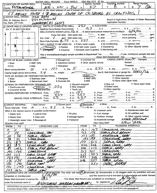
Specific Water Well Detail |
|
|
| Location Info | |||
| Owner: Bath, Jim | Status: Constructed | ||
| Location: T8S, R7E, Sec. 27, NE NW SW | County: Pottawatomie | ||
| Directions: from Olsburg: 1.5 mi S, 7 mi S | |||
| Latitude: 39.3262503 | Longitude: -96.6404907 | Datum NAD 27 | |
| Latitude: 39.3262469 | Longitude: -96.6407748 | Datum NAD 83 | |
| Longitude and latitude calculated by Survey from township-range-section-quarter calls. Only good to within the quarter call accuracy. | |||
| View well on interactive map | |||
| General Info | ||
| Well Depth: 257 ft. | Elevation: ft. | |
| Static Water Level: 160 ft. | Est. Yield: 1 gpm. | |
| Comp. Date: 16-Jun-2000 | Well Use: Domestic | |
| DWR Applic. #: | Other ID: | |
| Driller Info | ||
| Driller: Associated Environmental, Inc. | License #: 585 | |
| Scanned Form | View scan |
|
Chemical Sample Submitted?:
Water Well disinfected?: | ||
| Casing Info | ||
| Casing Type:
Casing Joints: |
Diam: in. to ft | |
| Casing height above land surface: in
Casing Weight: lbs/ft Wall thickness or gauge no.: | ||
| Screen and Perforation Info | ||
| Screen Type: | Screen Openings: | |
| Screen-perforated intervals | From: ft to ft | |
| Gravel pack intervals | From: ft to ft | |
| Grout Info | ||
| Grout used: | From: to ft | |
| Source of Possible Contamination | ||
| Source: | ||
| Direction from well: | Distance: ft | |
| Lithologic Log
(Log data entered by KGS.) | ||
| From: 0 ft. to 1 ft. | soil | |
| From: 1 ft. to 14 ft. | limestone, tan | |
| From: 14 ft. to 38 ft. | shale, brown | |
| From: 38 ft. to 56 ft. | limestone | |
| From: 56 ft. to 83 ft. | shale, gray | |
| From: 83 ft. to 87 ft. | limestone, gray | |
| From: 87 ft. to 102 ft. | shale, red brown | |
| From: 102 ft. to 105 ft. | limestone | |
| From: 105 ft. to 123 ft. | shale, light gray | |
| From: 123 ft. to 130 ft. | limestone, tan | |
| From: 130 ft. to 140 ft. | shale, tan | |
| From: 140 ft. to 143 ft. | limestone, tan | |
| From: 143 ft. to 162 ft. | shale, tan | |
| From: 162 ft. to 163 ft. | limestone, yellow | |
| From: 163 ft. to 175 ft. | shale, red-brown | |
| From: 175 ft. to 193 ft. | mudstone, gray | |
| From: 193 ft. to 199 ft. | limestone, gray | |
| From: 199 ft. to 205 ft. | shale, gray | |
| From: 205 ft. to 208 ft. | limestone, gray | |
| From: 208 ft. to 215 ft. | shale, gray | |
| From: 215 ft. to 217 ft. | limestone | |
| From: 217 ft. to 245 ft. | shale, gray | |
| From: 245 ft. to 246 ft. | limestone | |
| From: 246 ft. to 257 ft. | shale, gray | |