|
|
|
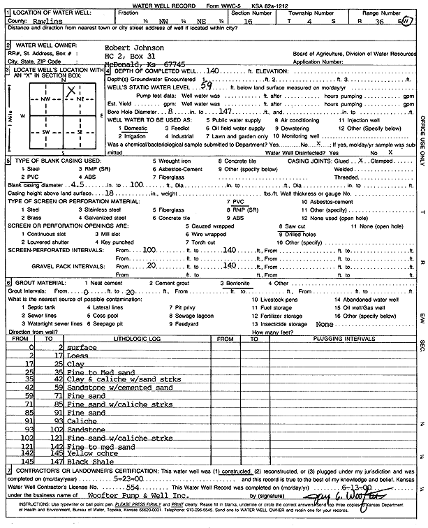
Specific Water Well Detail |
|
|
| Location Info | |||
| Owner: Johnson, Robert | Status: Constructed | ||
| Location: T4S, R36W, Sec. 16, NW NE | County: Rawlins | ||
| Directions: | |||
| Latitude: 39.7114656 | Longitude: -101.3614553 | Datum NAD 27 | |
| Latitude: 39.711463 | Longitude: -101.3618953 | Datum NAD 83 | |
| Longitude and latitude calculated by Survey from township-range-section-quarter calls. Only good to within the quarter call accuracy. | |||
| View well on interactive map | |||
| General Info | ||
| Well Depth: 140 ft. | Elevation: ft. | |
| Static Water Level: 59 ft. | Est. Yield: gpm. | |
| Comp. Date: 23-May-2000 | Well Use: Domestic | |
| DWR Applic. #: | Other ID: | |
| Driller Info | ||
| Driller: Jay C. Woofter Pump & Well, Inc. | License #: 554 | |
| Scanned Form | View scan |
|
Chemical Sample Submitted?:
Water Well disinfected?: | ||
| Casing Info | ||
| Casing Type:
Casing Joints: |
Diam: in. to ft | |
| Casing height above land surface: in
Casing Weight: lbs/ft Wall thickness or gauge no.: | ||
| Screen and Perforation Info | ||
| Screen Type: | Screen Openings: | |
| Screen-perforated intervals | From: ft to ft | |
| Gravel pack intervals | From: ft to ft | |
| Grout Info | ||
| Grout used: | From: to ft | |
| Source of Possible Contamination | ||
| Source: | ||
| Direction from well: | Distance: ft | |
| Lithologic Log
(Log data entered by KGS.) | ||
| From: 0 ft. to 2 ft. | surface | |
| From: 2 ft. to 17 ft. | loess | |
| From: 17 ft. to 25 ft. | clay | |
| From: 25 ft. to 35 ft. | fine to medium sand | |
| From: 35 ft. to 42 ft. | clay and caliche with sand streaks | |
| From: 42 ft. to 59 ft. | sandstone with cemented sand | |
| From: 59 ft. to 71 ft. | fine sand | |
| From: 71 ft. to 85 ft. | fine sand with caliche streaks | |
| From: 85 ft. to 91 ft. | fine sand | |
| From: 91 ft. to 93 ft. | caliche | |
| From: 93 ft. to 102 ft. | sandstone | |
| From: 102 ft. to 121 ft. | fine sand with caliche streaks | |
| From: 121 ft. to 142 ft. | fine to medium sand | |
| From: 142 ft. to 145 ft. | yellow ochre | |
| From: 145 ft. to 147 ft. | black shale | |