|
|
|
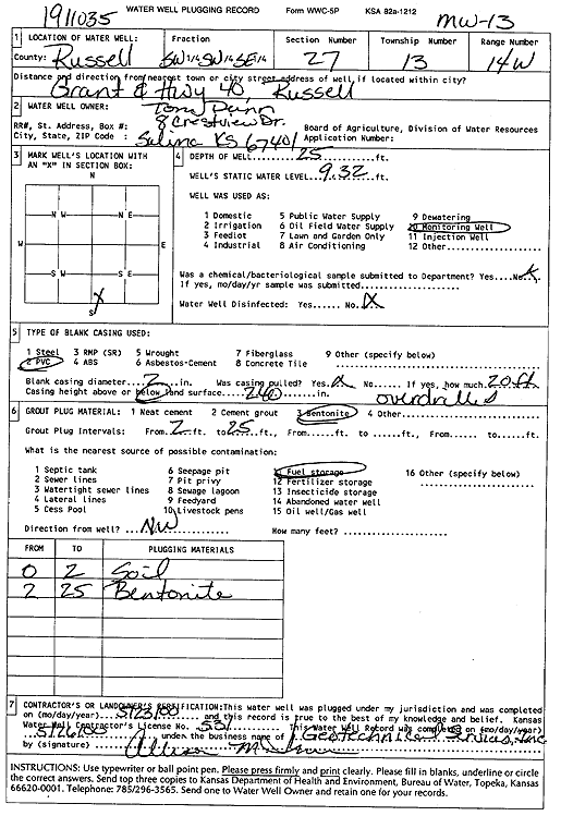
Specific Water Well Detail |
|
|
| Location Info | |||
| Owner: Dunn, Tom | Status: Plugged | ||
| Location: T13S, R14W, Sec. 27, SW SW SE | County: Russell | ||
| Directions: Grant and Hwy 40, Russell (id 1911035) | |||
| Latitude: 38.8865073 | Longitude: -98.862215 | Datum NAD 27 | |
| Latitude: 38.8864742 | Longitude: -98.8625768 | Datum NAD 83 | |
| Longitude and latitude calculated by Survey from township-range-section-quarter calls. Only good to within the quarter call accuracy. | |||
| View well on interactive map | |||
| General Info | ||
| Well Depth: 25 ft. | Elevation: ft. | |
| Static Water Level: 9.32 ft. | Est. Yield: gpm. | |
| Comp. Date: 23-May-2000 | Well Use: Monitoring well/observation/piezometer | |
| DWR Applic. #: | Other ID: MW 13 | |
| Driller Info | ||
| Driller: Geotechnical Services, Inc. | License #: 531 | |
| Scanned Form | View scan |
| Casing Info | ||
|
Casing Type:
Diam: in. Casing height above land surface: in | ||
| Grout Info | ||
| Grout used: | From: to ft | |
| Source of Possible Contamination | ||
| Source: | ||
| Direction from well: | Distance: ft | |