|
|
|
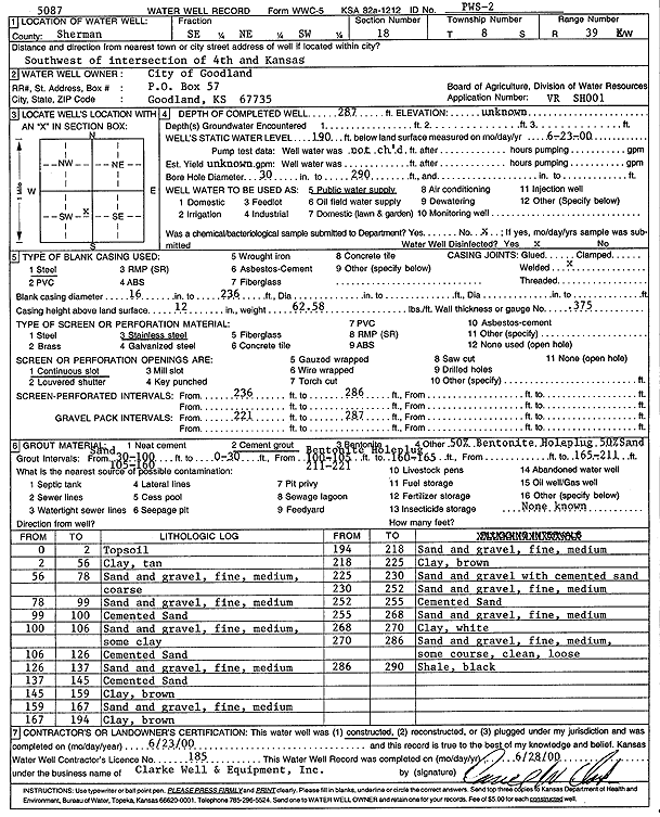
Specific Water Well Detail |
|
|
| Location Info | |||
| Owner: City of Goodland | Status: Constructed | ||
| Location: T8S, R39W, Sec. 18, SE NE SW | County: Sherman | ||
| Directions: Southwest of intersection of 4th and Kansas, Goodland | |||
| Latitude: 39.355726 | Longitude: -101.7173288 | Datum NAD 27 | |
| Latitude: 39.3557256 | Longitude: -101.717779 | Datum NAD 83 | |
| Longitude and latitude calculated by Survey from township-range-section-quarter calls. Only good to within the quarter call accuracy. | |||
| View well on interactive map | |||
| General Info | ||
| Well Depth: 287 ft. | Elevation: ft. | |
| Static Water Level: 190 ft. | Est. Yield: gpm. | |
| Comp. Date: 23-Jun-2000 | Well Use: Public Water Supply | |
| DWR Applic. #: SH0001 | Other ID: PWS 2 | |
| Driller Info | ||
| Driller: Clarke Well and Equipment, Inc. | License #: 185 | |
| Scanned Form | View scan |
|
Chemical Sample Submitted?:
Water Well disinfected?: | ||
| Casing Info | ||
| Casing Type:
Casing Joints: |
Diam: in. to ft | |
| Casing height above land surface: in
Casing Weight: lbs/ft Wall thickness or gauge no.: | ||
| Screen and Perforation Info | ||
| Screen Type: | Screen Openings: | |
| Screen-perforated intervals | From: ft to ft | |
| Gravel pack intervals | From: ft to ft | |
| Grout Info | ||
| Grout used: | From: to ft | |
| Source of Possible Contamination | ||
| Source: | ||
| Direction from well: | Distance: ft | |
| Lithologic Log
(Log data entered by KGS.) | ||
| From: 0 ft. to 2 ft. | Top soil | |
| From: 2 ft. to 56 ft. | Clay, tan | |
| From: 56 ft. to 78 ft. | Sand and gravel, fine, medium, coarse | |
| From: 78 ft. to 99 ft. | Sand and gravel, fine, medium | |
| From: 99 ft. to 100 ft. | Cemented sand | |
| From: 100 ft. to 106 ft. | Sand and gravel, fine, medium, some clay | |
| From: 106 ft. to 126 ft. | Cemented sand | |
| From: 126 ft. to 137 ft. | Sand and gravel, fine, medium | |
| From: 137 ft. to 145 ft. | Cemented sand | |
| From: 145 ft. to 159 ft. | Clay, brown | |
| From: 159 ft. to 167 ft. | Sand and gravel, fine, medium | |
| From: 167 ft. to 194 ft. | Clay, brown | |
| From: 194 ft. to 218 ft. | Sand and gravel, fine, medium | |
| From: 218 ft. to 225 ft. | Clay, brown | |
| From: 225 ft. to 230 ft. | Sand and gravel with cemented sand | |
| From: 230 ft. to 252 ft. | Sand and gravel, fine, medium | |
| From: 252 ft. to 255 ft. | Cemented sand | |
| From: 255 ft. to 268 ft. | Sand and gravel, fine, medium | |
| From: 268 ft. to 270 ft. | Clay, white | |
| From: 270 ft. to 286 ft. | Sand and gravel, fine, medium, some coarse, clean, loose | |
| From: 286 ft. to 290 ft. | Shale, black | |