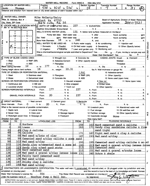
![]() |
![]() |
Specific Water Well Detail |
![]() |
Location Info | |||
Owner: McCarty, Mike | Status: Constructed | ||
Location: T7S, R31W, Sec. 18, SW NW SW | County: Thomas | ||
Directions: | |||
Latitude: 39.4424212 | Longitude: -100.8305691 | Datum NAD 27 | |
Latitude: 39.4424253 | Longitude: -100.830997 | Datum NAD 83 | |
Longitude and latitude calculated by Survey from township-range-section-quarter calls. Only good to within the quarter call accuracy. | |||
View well on interactive map |
General Info | ||
Well Depth: 237 ft. | Elevation: ft. | |
Static Water Level: 131 ft. | Est. Yield: gpm. | |
Comp. Date: 03-Mar-2000 | Well Use: Domestic, Livestock | |
DWR Applic. #: 20009121 | Other ID: |
Links | |
No Wizard information available. | |
View info from WIMAS Water Right Data base... |
Driller Info | ||
Driller: Jay C. Woofter Pump & Well, Inc. | License #: 554 |
Scanned Form | ||
View form(s) on screen | Download scan(s) | |
The download files contain one or more TIFF images compressed into a ZIP archive. Your browser may be already set up to decompress these files. The TIFFs are 300 dpi archival-quality scans of the WWC5 forms and can be viewed by software like Adobe PhotoShop. |
Chemical Sample Submitted?:
Water Well disinfected?: | ||
Casing Info | ||
Casing Type:
Casing Joints: |
Diam: in. to ft | |
Casing height above land surface: in
Casing Weight: lbs/ft Wall thickness or gauge no.: |
Screen and Perforation Info | ||
Screen Type: | Screen Openings: | |
Screen-perforated intervals | From: ft to ft | |
Gravel pack intervals | From: ft to ft |
Grout Info | ||
Grout used: | From: to ft |
Source of Possible Contamination | ||
Source: | ||
Direction from well: | Distance: ft |
Lithologic Log
(Log data entered by KGS.) | ||
From: 0 ft. to 2 ft. | Surface | |
From: 2 ft. to 20 ft. | Loess | |
From: 20 ft. to 49 ft. | Clay and caliche | |
From: 49 ft. to 56 ft. | Caliche | |
From: 56 ft. to 68 ft. | Medium sand with lots of clay | |
From: 68 ft. to 99 ft. | Cemented sand with clay caliche and some sand | |
From: 99 ft. to 103 ft. | Medium sand with clay | |
From: 103 ft. to 116 ft. | Sandy clay with cemented sand and some sand | |
From: 116 ft. to 123 ft. | Sandy clay with medium sand streaks | |
From: 123 ft. to 124 ft. | Hard cemented sand | |
From: 124 ft. to 128 ft. | Medium sand and gravel with clay lenses loose | |
From: 128 ft. to 134 ft. | Fairly hard cemented sand | |
From: 134 ft. to 136 ft. | Medium sand with clay | |
From: 136 ft. to 147 ft. | Sticky clay and caliche | |
From: 147 ft. to 159 ft. | Medium sand with clay | |
From: 159 ft. to 163 ft. | Hard Cemented sand and caliche | |
From: 163 ft. to 171 ft. | Sandy clay sandstone caliche and find sand tight | |
From: 171 ft. to 187 ft. | Tight medium sand and clay and caliche | |
From: 187 ft. to 193 ft. | Medium sand with clay | |
From: 193 ft. to 195 ft. | Cemented sand with clay caliche and some sand | |
From: 195 ft. to 213 ft. | Medium sand and gravel with clay lenses loose | |
From: 213 ft. to 215 ft. | Cemented sand | |
From: 215 ft. to 231 ft. | Medium sand and gravel with rocks loose | |
From: 231 ft. to 240 ft. | Ochre and shale |